IMAGES TAKEN NEAR TO
Cudworth, ILMINSTER, TA19 0PR
Introduction
This page details the photographs taken nearby to TA19 0PR by members of the Geograph project.
The Geograph project started in 2005 with the aim of publishing, organising and preserving representative images for every square kilometre of Great Britain, Ireland and the Isle of Man.

There are currently over 7.5m images from over14,400 individuals and you can help contribute to the project by visiting https://www.geograph.org.uk
Image Map (Loading...)


Getting Data...Please wait
Leaflet Map data © OpenStreetMap
Images are licensed for reuse under creativecommons.org/licenses/by-sa/2.0
Notes
- Clicking on the map will re-center to the selected point.
- The higher the marker number, the further away the image location is from the centre of the postcode.
Image Listing (13 Images Found)
Images are licensed for reuse under creativecommons.org/licenses/by-sa/2.0
Image
Details
Distance
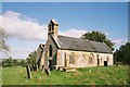
1
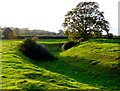
Moat near Cudworth
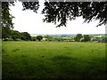
This moat just to the south of the church at Cudworth is probably the remains of a fortified manor house although there is very little in the way of remains inside the moat. The moat is approximately circular and is approximately 75m to 80m in diameter. The interior is slightly higher than the surrounding field. This is the west side of the moat looking north west from just outside the moat on the southern side. There are the remains of fishponds in the adjacent field. Further details can be found here http://www.gatehouse-gazetteer.info/English%20sites/3867.html
Image: © Nigel Mykura
Taken: 17 Oct 2009
0.08 miles
2
Cudworth Moat
A view of the western side of the moat looking south, showing in the foreground the earthwork in the moat where the entrance point may have been.
Image: © Nigel Mykura
Taken: 17 Oct 2009
0.09 miles
3
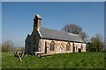
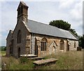
St Michael's Church, Cudworth
There is an Ordnance Survey benchmark on this building, see Image
Image: © Becky Williamson
Taken: 8 Apr 2017
0.10 miles
6
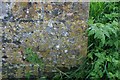
Benchmark on St Michael's Church, Cudworth
Ordnance Survey benchmark, described on database at http://www.bench-marks.org.uk/bm83454. See also Image
Image: © Becky Williamson
Taken: 8 Apr 2017
0.13 miles
9
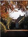
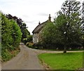
Autumn leaves
A pretty autumn view looking down lane towards Dowlish Wake. West farm and turning for Cudworth on the right.
Image: © John Walker
Taken: 2 Nov 2007
0.18 miles