IMAGES TAKEN NEAR TO
Cricket Lane, ILMINSTER, TA19 0PL
Introduction
This page details the photographs taken nearby to Cricket Lane, TA19 0PL by members of the Geograph project.
The Geograph project started in 2005 with the aim of publishing, organising and preserving representative images for every square kilometre of Great Britain, Ireland and the Isle of Man.

There are currently over 7.5m images from over14,400 individuals and you can help contribute to the project by visiting https://www.geograph.org.uk
Image Map (Loading...)


Getting Data...Please wait
Leaflet Map data © OpenStreetMap
Images are licensed for reuse under creativecommons.org/licenses/by-sa/2.0
Notes
- Clicking on the map will re-center to the selected point.
- The higher the marker number, the further away the image location is from the centre of the postcode.
Image Listing (2 Images Found)
Images are licensed for reuse under creativecommons.org/licenses/by-sa/2.0
Image
Details
Distance
1
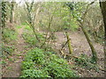
Remains of Chard Canal near Dowlish Ford
The wooded line of the canal has here been made into a nature reserve.
Image: © Derek Harper
Taken: 22 Apr 2006
0.10 miles
2

Old Milestone by the A3037, Greenway, Dowlish Ford
Stone post (plate lost) by the A3037, in parish of ILMINSTER (SOUTH SOMERSET District), Greenway, Dowlish Ford village, beside road in grass, on North side of road. Ilminster iron plate, erected by the Ilminster turnpike trust in the 19th century.
Inscription reads:-
: ILMINSTER / 1 : : CHARD / 4 :
Carved benchmark on East face.
Grade II listed.
List Entry Number: 1295532 https://historicengland.org.uk/listing/the-list/list-entry/1295532
Milestone Society National ID: SO_IMCH01.
Image: © JR Dowding
Taken: 1 Sep 2002
0.20 miles