IMAGES TAKEN NEAR TO
The Mead, ILMINSTER, TA19 0HG
Introduction
This page details the photographs taken nearby to The Mead, TA19 0HG by members of the Geograph project.
The Geograph project started in 2005 with the aim of publishing, organising and preserving representative images for every square kilometre of Great Britain, Ireland and the Isle of Man.

There are currently over 7.5m images from over14,400 individuals and you can help contribute to the project by visiting https://www.geograph.org.uk
Image Map (Loading...)


Getting Data...Please wait
Leaflet Map data © OpenStreetMap
Images are licensed for reuse under creativecommons.org/licenses/by-sa/2.0
Notes
- Clicking on the map will re-center to the selected point.
- The higher the marker number, the further away the image location is from the centre of the postcode.
Image Listing (16 Images Found)
Images are licensed for reuse under creativecommons.org/licenses/by-sa/2.0
Image
Details
Distance
1
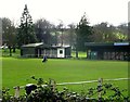
The Recreation Ground, home of Ilminster Town FC
The team play in the Somerset County League.
Image: © nick macneill
Taken: 9 Mar 2013
0.10 miles
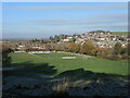
2
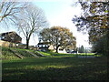
Ilminster Recreation Ground
The town's expansive grounds, with several pavilions and other associated buildings.
Image: © Neil Owen
Taken: 9 Dec 2022
0.11 miles
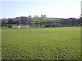
3
Where the lads play
Looking down at the recreation ground, home of Ilminster Town F.C. It lies just the south side of the old Chard Canal.
Image: © Neil Owen
Taken: 9 Dec 2022
0.11 miles
4
Old wrought iron gate at the Recreation Ground
An older style of gate work at the Recreation Ground.
Image: © Neil Owen
Taken: 9 Dec 2022
0.15 miles
5
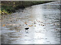
Too cold for the coots
The last water-filled section of the old Chard Canal lies at the south of the town. Whilst most of the old course has been drained, dug up and built over, this is the one bit that attracts the wildlife. However, a frosty morning has thwarted the coots.
Image: © Neil Owen
Taken: 9 Dec 2022
0.15 miles
6
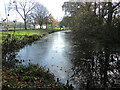
A little piece of the Chard Canal
The Chard Canal was hoped to provide an extra route for the expanding canal system in the South West in the early 1800s. The canal was opened in 1842 but due to the elevated nature and difficult terrain, was beset with financial and logistical problems from the beginning. It closed in 1868 and was largely dug up. This short section in south Ilminster is perhaps the only bit still with water in it - and forms a little wildlife retreat. See Image
Image: © Neil Owen
Taken: 9 Dec 2022
0.15 miles
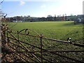
7
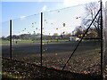
Leaves on the tennis courts
The fencing holds a few golden leaves whilst most have lined the courts. Beyond are the open fields of the Recreation Ground.
Image: © Neil Owen
Taken: 9 Dec 2022
0.16 miles
8
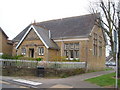
Ilminster Library
On Ditton Road, south of the town centre. The tablet in the gable reads "The Reading Room, 1889".
Image: © Derek Harper
Taken: 22 Apr 2006
0.18 miles
9
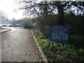
West Crescent park
A narrow corridor marks the edge of town and hosts a little play area for the children. The steep slope is actually part of the old Chard Canal and there was a short tunnel in this section.
Image: © Neil Owen
Taken: 9 Dec 2022
0.18 miles
10
Bingo at the footy
Ilminster Town's ground at Britten's Field, with a fund-raiser event in the clubhouse advertised.
Image: © Neil Owen
Taken: 9 Dec 2022
0.18 miles