IMAGES TAKEN NEAR TO
Roundham, CREWKERNE, TA18 8RR
Introduction
This page details the photographs taken nearby to TA18 8RR by members of the Geograph project.
The Geograph project started in 2005 with the aim of publishing, organising and preserving representative images for every square kilometre of Great Britain, Ireland and the Isle of Man.

There are currently over 7.5m images from over14,400 individuals and you can help contribute to the project by visiting https://www.geograph.org.uk
Image Map (Loading...)


Getting Data...Please wait
Leaflet Map data © OpenStreetMap
Images are licensed for reuse under creativecommons.org/licenses/by-sa/2.0
Notes
- Clicking on the map will re-center to the selected point.
- The higher the marker number, the further away the image location is from the centre of the postcode.
Image Listing (2 Images Found)
Images are licensed for reuse under creativecommons.org/licenses/by-sa/2.0
Image
Details
Distance
1
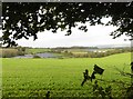
Coombe
The right hand part of the large farm is in ST4109. The history is outlined at http://webapp1.somerset.gov.uk/her/details.asp?prn=54694 , which describes it as a deserted medieval village. Certainly the slopes of St Rayn Hill, beyond, appear to show signs of human activity. Along the edge of the wood at the top runs the A30.
Image: © Derek Harper
Taken: 28 Jul 2007
0.13 miles