IMAGES TAKEN NEAR TO
Cathole Bridge Road, CREWKERNE, TA18 8RF
Introduction
This page details the photographs taken nearby to Cathole Bridge Road, TA18 8RF by members of the Geograph project.
The Geograph project started in 2005 with the aim of publishing, organising and preserving representative images for every square kilometre of Great Britain, Ireland and the Isle of Man.

There are currently over 7.5m images from over14,400 individuals and you can help contribute to the project by visiting https://www.geograph.org.uk
Image Map (Loading...)


Getting Data...Please wait
Leaflet Map data © OpenStreetMap
Images are licensed for reuse under creativecommons.org/licenses/by-sa/2.0
Notes
- Clicking on the map will re-center to the selected point.
- The higher the marker number, the further away the image location is from the centre of the postcode.
Image Listing (7 Images Found)
Images are licensed for reuse under creativecommons.org/licenses/by-sa/2.0
Image
Details
Distance
1
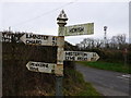
Signpost near Hewish and Crewkerne
This is on a minor road just south of Crewkwerne. The reason the sign for Hewish is different to the others is that when the signs were made, the Hewish sign was spelled incorrectly as "HUISH" (the spelling used for the far more famous Yeovil Town Football Club ground 10 miles away at Yeovil) and had to be replaced. The sign was replaced in 2009.
The name Huish is common in Somerset (where it can be found 21 times in various forms) but is not at all common elsewhere in the country. It seems to have meant ‘household’ or ‘family farm’ many hundreds of years ago. It has been suggested that places with this name are what is left of a pre-Saxon, farmstead settlement pattern that existed before villages became the norm. This farmstead pattern was replaced by planned open-field villages in the later Saxon period.
Image: © Nigel Mykura
Taken: 15 Jan 2008
0.05 miles
2
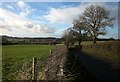
Cathole Bridge Road
Seen from close to Brightwell Farm, and heavily used to connect the A30 and the A346 avoiding Crewkerne.
Image: © Derek Harper
Taken: 24 Feb 2015
0.06 miles
4
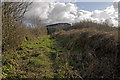
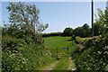
Brightwell Farm, footpath leading to Cathole Lane.
The "farm" buildings in the background are home to a factory producing plastic mouldings.
Image: © Rabbi WP Thinrod
Taken: 6 Feb 2008
0.08 miles
5
Field Entrance Curriott Hill
They obviously wanted to keep people out of this field. There is a double gate, one of which the photographer is leaning over and the one in the image. It has two signs on it. One says "trespassers will be prosecuted" and the other "Danger Asbestos". Someone had scrawled in large felt tip letters across the first sign "Log Thief" whatever that means. There was no sign of anything except grass in the field.
Image: © Nigel Mykura
Taken: 16 May 2015
0.12 miles
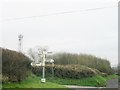
6
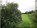
Entrance to a grass field off Hewish Lane
Image: © Jonathan Thacker
Taken: 19 Sep 2018
0.13 miles
7
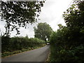
Hewish Lane
Just outside Crewkerne.
Image: © Jonathan Thacker
Taken: 19 Sep 2018
0.15 miles