IMAGES TAKEN NEAR TO
Park View, CREWKERNE, TA18 8JL
Introduction
This page details the photographs taken nearby to Park View, TA18 8JL by members of the Geograph project.
The Geograph project started in 2005 with the aim of publishing, organising and preserving representative images for every square kilometre of Great Britain, Ireland and the Isle of Man.

There are currently over 7.5m images from over14,400 individuals and you can help contribute to the project by visiting https://www.geograph.org.uk
Image Map
Images are licensed for reuse under creativecommons.org/licenses/by-sa/2.0
Notes
- Clicking on the map will re-center to the selected point.
- The higher the marker number, the further away the image location is from the centre of the postcode.
Image Listing (2 Images Found)
Images are licensed for reuse under creativecommons.org/licenses/by-sa/2.0
Image
Details
Distance
1
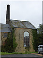
Viney Bridge Mills, Crewkerne
A complex of stone built mills including an engine house and square chimney. Produced canvas and webbing but now in multiple occupancy. This shows the chimney and engine house with the characteristic large window. Typically, these could be removed to allow engine parts to pass through during construction.
Image: © Chris Allen
Taken: 6 Nov 2015
0.24 miles
2
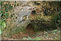
Small cave near Crewkerne
Small natural cave and rock shelter in the railway cutting near Crewkerne Station.The cave is marked on the 1890's O.S. map.
Image: © Nick Chipchase
Taken: 4 Jan 2013
0.25 miles