IMAGES TAKEN NEAR TO
Valley Road, CREWKERNE, TA18 8DT
Introduction
This page details the photographs taken nearby to Valley Road, TA18 8DT by members of the Geograph project.
The Geograph project started in 2005 with the aim of publishing, organising and preserving representative images for every square kilometre of Great Britain, Ireland and the Isle of Man.

There are currently over 7.5m images from over14,400 individuals and you can help contribute to the project by visiting https://www.geograph.org.uk
Image Map
Images are licensed for reuse under creativecommons.org/licenses/by-sa/2.0
Notes
- Clicking on the map will re-center to the selected point.
- The higher the marker number, the further away the image location is from the centre of the postcode.
Image Listing (4 Images Found)
Images are licensed for reuse under creativecommons.org/licenses/by-sa/2.0
Image
Details
Distance
1
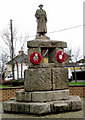
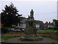
War Memorial, Severalls Park Avenue, Crewkerne
This war memorial is tucked away in a residential area up on Curriott Hill near the park. It must have been erected before most of the houses were built so was probably standing alone in earlier years.
Image: © Sarah Smith
Taken: 28 Jan 2009
0.11 miles
3

The Orange Way in Dorset and Somerset (94)
The Way approaches a roundabout on Hermitage Street. On the left is a pump outside Pump Cottage.
Image: © Shazz
Taken: 3 Jul 2012
0.22 miles
4
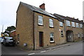
Junction of Hermitage Street and Dairy Court
Image: © Roger Templeman
Taken: 30 Mar 2015
0.22 miles