IMAGES TAKEN NEAR TO
Marks Barn, CREWKERNE, TA18 7TS
Introduction
This page details the photographs taken nearby to TA18 7TS by members of the Geograph project.
The Geograph project started in 2005 with the aim of publishing, organising and preserving representative images for every square kilometre of Great Britain, Ireland and the Isle of Man.

There are currently over 7.5m images from over14,400 individuals and you can help contribute to the project by visiting https://www.geograph.org.uk
Image Map (Loading...)


Getting Data...Please wait
Leaflet Map data © OpenStreetMap
Images are licensed for reuse under creativecommons.org/licenses/by-sa/2.0
Notes
- Clicking on the map will re-center to the selected point.
- The higher the marker number, the further away the image location is from the centre of the postcode.
Image Listing (10 Images Found)
Images are licensed for reuse under creativecommons.org/licenses/by-sa/2.0
Image
Details
Distance

2
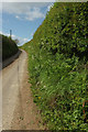
Lane to Furland
Image: © Derek Harper
Taken: 27 Apr 2019
0.17 miles
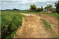
3
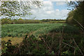
Crop by Moorlands Road
Moorlands Road runs along the far side of this field, on this side of the cattle. This view from the lane from Shutteroaks, which could be Moorlands Road as well.
Image: © Derek Harper
Taken: 27 Apr 2019
0.18 miles
4
Lane to Merriott
Image: © Derek Harper
Taken: 27 Apr 2019
0.18 miles
5
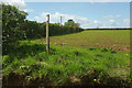
Arable field near Shutteroaks
The notice states "No", but the rest has disappeared.
Image: © Derek Harper
Taken: 27 Apr 2019
0.18 miles
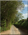
6
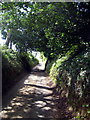
Leafy lane near Marks Barn
Just past the bend and the turning to Barn Lane, Moorlands Road gets narrower and the trees growing on the banks on either side of the road touch overhead.
Image: © Sarah Smith
Taken: 28 Aug 2009
0.18 miles
7
Field entrance near Shutteroaks
A track leads into the field shown in Image
Image: © Derek Harper
Taken: 27 Apr 2019
0.20 miles
8
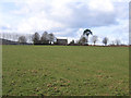
Shutteroaks, Merriott, Somerset
– view W across the centre of the square from near Barn Lane.
Image: © Rodney Burton
Taken: 2 Mar 2006
0.22 miles
9
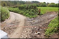
Ropes across Hinton Road
Somewhat unexpected; a pair of ropes have been stretched across the lane to ensure cattle head from one field to another rather than along the lane. They're fairly tight, so I was worried about snapping them, but they were at a perfect level for a normal saloon car to creep very gently beneath. The trees in the background are along Ford's Croft Goil. See http://www.yeovilhistory.info/lydegurl.htm : "'Gurl', also found as goyle, goil, goyal and guile, is a Somerset dialect word meaning a ravine, gully or steep-sided narrow valley usually with a stream running down". See also Image
Image: © Derek Harper
Taken: 27 Apr 2019
0.25 miles
10

Rope across Hinton Road
Looking up the lane shown in Image], with one of the ropes crossing the lane, which is climbing towards the junction shown in Image The rope remains intact after my car's passage beneath it.
Image: © Derek Harper
Taken: 27 Apr 2019
0.25 miles