IMAGES TAKEN NEAR TO
North Street, CREWKERNE, TA18 7RP
Introduction
This page details the photographs taken nearby to North Street, TA18 7RP by members of the Geograph project.
The Geograph project started in 2005 with the aim of publishing, organising and preserving representative images for every square kilometre of Great Britain, Ireland and the Isle of Man.

There are currently over 7.5m images from over14,400 individuals and you can help contribute to the project by visiting https://www.geograph.org.uk
Image Map (Loading...)


Getting Data...Please wait
Leaflet Map data © OpenStreetMap
Images are licensed for reuse under creativecommons.org/licenses/by-sa/2.0
Notes
- Clicking on the map will re-center to the selected point.
- The higher the marker number, the further away the image location is from the centre of the postcode.
Image Listing (21 Images Found)
Images are licensed for reuse under creativecommons.org/licenses/by-sa/2.0
Image
Details
Distance
1
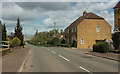
North Street, Haselbury Plucknett
The A3066 passes the junction with New Lane (right).
Image: © Derek Harper
Taken: 27 Apr 2019
0.01 miles
2
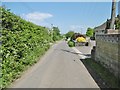
Haselbury Plucknett, New Lane
Lane on the northern edge of the village, leading to Claycastle Lane.
Image: © Mike Faherty
Taken: 19 May 2018
0.02 miles
3
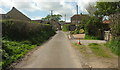
New Lane
Approaching Haselbury Plucknett and the A3066, seen from the same spot as Image] looking the other way.
Image: © Derek Harper
Taken: 27 Apr 2019
0.03 miles
4
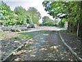
Haselbury Plucknett, works
Sewage treatment works off New Lane.
Image: © Mike Faherty
Taken: 19 May 2018
0.06 miles
5
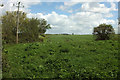
Farmland by New Lane
A small meadow in the foreground sites to the west of the sewage works (off to the right). Ahead is the curving hedge beside New Lane, as shown in Image
Image: © Derek Harper
Taken: 27 Apr 2019
0.06 miles
6
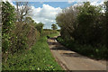
New Lane
Running eastwards from the A3066 in Haselbury Plucknett. The sewage works shown in Image is just off to the right here.
Image: © Derek Harper
Taken: 27 Apr 2019
0.08 miles
7
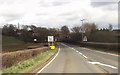
Haselbury Plucknett from A30
Bridport road comes in from the right - the A3066
Image: © John Firth
Taken: 12 Apr 2013
0.08 miles
8
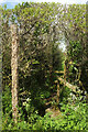
Footpath from New Lane
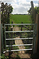
Corresponding to Image] on the other side of the lane, this is footpath 40UD047 Y 11/11, starting with a ditch footbridge and then a stile.
Image: © Derek Harper
Taken: 27 Apr 2019
0.14 miles
9
Footpath from New Lane
Footpath 40UD047 Y 11/12 starts with a gate and then a footbridge over a ditch (which the signpost seems to be pointing into). On the other side of the lane, a footpath continues, as shown in Image
Image: © Derek Harper
Taken: 27 Apr 2019
0.15 miles
10
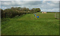
Pasture near Haselbury Plucknett
The scene on the other side of the stile seen in Image The footpath, 40UD047 Y 11/11, follows the line between the hedge and the fencing.
Image: © Derek Harper
Taken: 27 Apr 2019
0.16 miles