IMAGES TAKEN NEAR TO
Middle Chinnock, CREWKERNE, TA18 7PR
Introduction
This page details the photographs taken nearby to TA18 7PR by members of the Geograph project.
The Geograph project started in 2005 with the aim of publishing, organising and preserving representative images for every square kilometre of Great Britain, Ireland and the Isle of Man.

There are currently over 7.5m images from over14,400 individuals and you can help contribute to the project by visiting https://www.geograph.org.uk
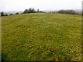
Image Map (Loading...)


Getting Data...Please wait
Leaflet Map data © OpenStreetMap
Images are licensed for reuse under creativecommons.org/licenses/by-sa/2.0
Notes
- Clicking on the map will re-center to the selected point.
- The higher the marker number, the further away the image location is from the centre of the postcode.
Image Listing (13 Images Found)
Images are licensed for reuse under creativecommons.org/licenses/by-sa/2.0
Image
Details
Distance
1
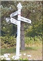
Direction Sign - Signpost by Lower Street, West Chinnock Parish
Pyramid finial - 3 arms; Somerset SCC pyramid by the UC road, in parish of West Chinnock (South Somerset District), junction of Lower Street, Hollowell Hill and Smiths Hill.
Surveyed
Milestone Society National ID: SO_ST4613C
Image: © J Dowding
Taken: Unknown
0.17 miles
3
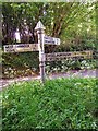
Direction Sign - Signpost below Balham Hill
Pyramid finial - 3 arms; Somerset SCC pyramid by the UC road, in parish of Chiselborough (South Somerset District), Skillgate Lane junction with Behind Butts and Hollowell Hill, on small grass island.
Surveyed
Milestone Society National ID: SO_ST4614
Image: © Milestone Society
Taken: Unknown
0.18 miles
4

The Old Village Garage
Long time since these dispensed any petrol but they are still there sheltering in the small ham stone hut that once kept rural motorists on the lanes. See Image
Image: © Nigel Mykura
Taken: 2 May 2013
0.19 miles
5
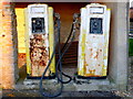
Old Petrol Pumps
Part of the reason these pumps have survived is that they are sheltering in a solid stone built hut with a good tiled roof. See Image
Image: © Nigel Mykura
Taken: 2 May 2013
0.19 miles
6
Brympton Hill
Field gate from Smoley Hole Lane to east then followed the fence line that then involved tricky crossing of fence/hedge towards the top.
Name: Brympton Hill
Hill number: 18265
Height: 115m / 377ft
Parent (Ma/M): 2896 Lewesdon Hill
Section: 41: South Central England
County/UA: Somerset (CoU)
Class: Tump (100-199m)
Grid ref: ST471143 (est)
Drop: 41m
Col: 74m ST475142
Image: © Rude Health
Taken: 29 Mar 2015
0.19 miles
7
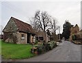
Former garage and preserved fuel pumps, West Chinnock
Image: © Roger Cornfoot
Taken: 21 Dec 2016
0.20 miles
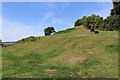
8
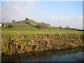
Balham Hill
Balham Hill across the river Parrett at Byme Bridge.
Image: © Rupert Fleetingly
Taken: 28 Dec 2005
0.22 miles
9
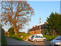
Houses on Smith's Hill
These appear to be ex council houses. Because they are set back from the road without parking there is allocated parking adjacent to the road and next to a small children's play ground.
Image: © Nigel Mykura
Taken: 2 May 2013
0.23 miles
10
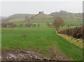
View through the mist towards Balham Hill
Image: © Roger Cornfoot
Taken: 21 Dec 2016
0.23 miles