IMAGES TAKEN NEAR TO
Redgate Park, CREWKERNE, TA18 7NL
Introduction
This page details the photographs taken nearby to Redgate Park, TA18 7NL by members of the Geograph project.
The Geograph project started in 2005 with the aim of publishing, organising and preserving representative images for every square kilometre of Great Britain, Ireland and the Isle of Man.

There are currently over 7.5m images from over14,400 individuals and you can help contribute to the project by visiting https://www.geograph.org.uk
Image Map (Loading...)


Getting Data...Please wait
Leaflet Map data © OpenStreetMap
Images are licensed for reuse under creativecommons.org/licenses/by-sa/2.0
Notes
- Clicking on the map will re-center to the selected point.
- The higher the marker number, the further away the image location is from the centre of the postcode.
Image Listing (4 Images Found)
Images are licensed for reuse under creativecommons.org/licenses/by-sa/2.0
Image
Details
Distance
2
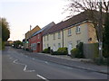
New Houses on North St.
North St becomes the Broadshard Rd at about this point. It is also the A356, the main road out of the town to the north and the A303.
Image: © Nigel Mykura
Taken: 2 May 2013
0.14 miles
3
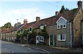
Terraced houses North Street Crewkerne
These houses are close to the junction of Ashlands Road with North Street. The modern houses of Ashlands Close are just visible over the rooftops on the right.
Image: © Sarah Smith
Taken: 28 May 2009
0.14 miles