IMAGES TAKEN NEAR TO
East Street, CREWKERNE, TA18 7LW
Introduction
This page details the photographs taken nearby to East Street, TA18 7LW by members of the Geograph project.
The Geograph project started in 2005 with the aim of publishing, organising and preserving representative images for every square kilometre of Great Britain, Ireland and the Isle of Man.

There are currently over 7.5m images from over14,400 individuals and you can help contribute to the project by visiting https://www.geograph.org.uk
Image Map (Loading...)


Getting Data...Please wait
Leaflet Map data © OpenStreetMap
Images are licensed for reuse under creativecommons.org/licenses/by-sa/2.0
Notes
- Clicking on the map will re-center to the selected point.
- The higher the marker number, the further away the image location is from the centre of the postcode.
Image Listing (248 Images Found)
Images are licensed for reuse under creativecommons.org/licenses/by-sa/2.0
Image
Details
Distance
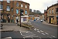
1
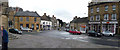
Crewkerne : East Street
East Street and roundabout in Crewkerne includes shops Mckinlays, Hair and Beauty, HSBC and Palmer Snell.
Image: © Lewis Clarke
Taken: 14 Apr 2009
0.01 miles
2

Crewkerne Marathon 1999
The competitors line up to run several miles around Crewkerne and the surrounding countryside.
Image: © Sarah Smith
Taken: Unknown
0.02 miles
3

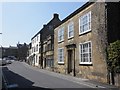
Market Square, Crewkerne
The White Hart hotel, originally a late C16 house, is now a hotel and listed Grade II. Next door to the right is Crewkerne Museum
Image: © Eirian Evans
Taken: 27 Oct 2021
0.02 miles
5
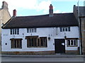
The White Hart, Crewkerne
The White Hart is the oldest pub in Crewkerne
dating from the 16th century as stated on the
Civic Society plaque on the wall on the far left
of the building.
Image: © Andy Pearce
Taken: 24 Mar 2008
0.02 miles
6
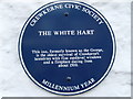
The White Hart, Crewkerne
The civic society plaque on the wall
of the White Hart.
Image: © Andy Pearce
Taken: 24 Mar 2008
0.02 miles
7
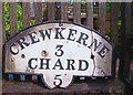
Old Milestone Plate, Crewkerne Museum, Market Square, Crewekerne
The plate was attached to a milestone, lost since 1970, located on the A30, St Rayn Hill, Chillington Image, on the north side of the road. Parish of Crewkerne (South Somerset District). Metal plate attached to stone post, Chard plate design, erected by the Chard turnpike trust in the 19th century.
Inscription reads:-
CREWKERNE
3
CHARD
5
Somerset HER.
HER number: 14800 https://www.heritagegateway.org.uk/Gateway/Results_Single.aspx?uid=14800&resourceID=100
Milestone Society National ID: SO_CHCW05P
Image: © JR Dowding
Taken: 1 Jul 2015
0.02 miles
8
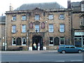
The George Hotel
This building dates from 1832. The archway leads to the stable
courtyard, reminders that this was once a Royal Mail coaching inn.
The previous pub called The George is along the street to the left
and is now The White Hart.
Image: © Andy Pearce
Taken: 24 Mar 2008
0.02 miles
9
Crewkerne: The A30 in the direction of Yeovil
Image: © Mr Eugene Birchall
Taken: 21 Feb 2010
0.02 miles
10
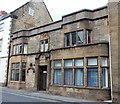
Richmond House, East Street, Crewkrne
An interesting design from 1902 squeezing in between much older buildings.
Image: © Bill Harrison
Taken: 11 Jul 2016
0.03 miles