IMAGES TAKEN NEAR TO
Gouldsbarton, CREWKERNE, TA18 7HT
Introduction
This page details the photographs taken nearby to Gouldsbarton, TA18 7HT by members of the Geograph project.
The Geograph project started in 2005 with the aim of publishing, organising and preserving representative images for every square kilometre of Great Britain, Ireland and the Isle of Man.

There are currently over 7.5m images from over14,400 individuals and you can help contribute to the project by visiting https://www.geograph.org.uk
Image Map (Loading...)


Getting Data...Please wait
Leaflet Map data © OpenStreetMap
Images are licensed for reuse under creativecommons.org/licenses/by-sa/2.0
Notes
- Clicking on the map will re-center to the selected point.
- The higher the marker number, the further away the image location is from the centre of the postcode.
Image Listing (241 Images Found)
Images are licensed for reuse under creativecommons.org/licenses/by-sa/2.0
Image
Details
Distance
1
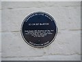
12 Court Barton - Blue Plaque
There is now a Gang Show Fellowship which offers financial assistance to individuals in the Scout and Guide movements wanting to pursue a particular activity.
Image: © Sarah Smith
Taken: 23 Jul 2008
0.01 miles
3
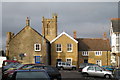
Court Barton, Crewkerne
A pleasant square just off the one-way system of Church Street and with West Street to the south. The tower of St Bartholomew's can be seen behind the houses.
Image: © Sarah Smith
Taken: 28 Jan 2009
0.02 miles
4
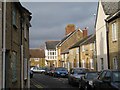
Court Barton - east side
The road runs behind me out to West Street. Ye Shelle House built in 1893 can be seen at the end on the right with its upper floor and windows projecting on to the street.
Image: © Sarah Smith
Taken: 28 Jan 2009
0.02 miles
5
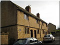
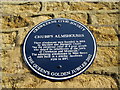
Chubb's Almshouses, Crewkerne
Mathew Chubb was a gentleman and former Member of Parliament of Dorchester who provided the money for these almshouses to be built in 1604. He also built one in Shaftesbury in 1611 (his wife's family came from there) and another in Dorchester in North Square, but not until 1620 - please see Image
Image: © Sarah Smith
Taken: 28 Jan 2009
0.02 miles
6
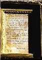
Chubb's Almshouses - inscription
The stone inscription reads:
"To the honor of God and for the relief of the poore people of the towne of Cr., this house was built by Mathew Chubb, of Dorchester,in the C of D,Gent,and Margaret his wife, in Ano Domini 1604.
'Blessed is he that considereth the poore and needie.
The Lord will delivereth him in the tyme of trouble.'
Psalm 41"
Image: © Sarah Smith
Taken: 28 Jan 2009
0.02 miles
7
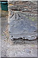
Benchmark on wall pier at The Rectory entrance
Ordnance Survey cut mark benchmark described on the Bench Mark Database at http://www.bench-marks.org.uk/bm65639
Image: © Roger Templeman
Taken: 30 Mar 2015
0.03 miles
8
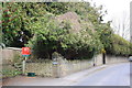
Entrance to The Rectory and Glebe Cottage
There is an OS benchmark Image on the road face of the wall pier which carries the house name signs
Image: © Roger Templeman
Taken: 30 Mar 2015
0.03 miles
9
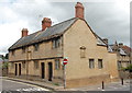
Chubb's Almshouses, Crewkerne
The 'old' block from the early 17th Century. Grade-II listed (ref. 1208709):
https://www.britishlistedbuildings.co.uk/101208709-chubbs-almshouseschubbs-almshouses-and-attached-wall-crewkerne#.WjwnySZLGAg .
Image: © Bill Harrison
Taken: 11 Jul 2016
0.03 miles
10
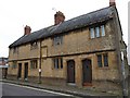
Chubb's Almshouses, Crewkerne
Another view of Image from the junction of Court Barton with West Street. This is the earlier of two four-unit blocks. http://www.imagesofengland.org.uk/Details/Default.aspx?id=390446&mode=adv
Image: © Derek Harper
Taken: 15 Sep 2009
0.03 miles