IMAGES TAKEN NEAR TO
Church Street, CREWKERNE, TA18 7HR
Introduction
This page details the photographs taken nearby to Church Street, TA18 7HR by members of the Geograph project.
The Geograph project started in 2005 with the aim of publishing, organising and preserving representative images for every square kilometre of Great Britain, Ireland and the Isle of Man.

There are currently over 7.5m images from over14,400 individuals and you can help contribute to the project by visiting https://www.geograph.org.uk
Image Map
Images are licensed for reuse under creativecommons.org/licenses/by-sa/2.0
Notes
- Clicking on the map will re-center to the selected point.
- The higher the marker number, the further away the image location is from the centre of the postcode.
Image Listing (245 Images Found)
Images are licensed for reuse under creativecommons.org/licenses/by-sa/2.0
Image
Details
Distance
1
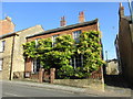
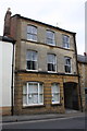
Wisteria covered house, Church Street, Crewkerne
Image: © Jonathan Thacker
Taken: 12 Sep 2017
0.01 miles
2
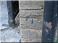
Ordnance Survey Cut Mark
This mark can be found on the wall of a dwelling in Church Street, Crewkerne.
For more detail see : http://www.bench-marks.org.uk/bm56689
Image: © Peter Wood
Taken: 1 Apr 2014
0.01 miles
5
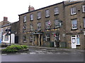
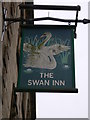
The Swan Inn, Crewkerne
The inn dates from the 17th and 18th centuries with remodelling in the late 19th century. It has a Ham Hill stone ashlar façade. In 1751 there were 35 hostelries in Crewkerne. The Swan Hotel was among the four most important, and was described as "newly built" in 1774.
Image: © mike smith
Taken: 6 Aug 2013
0.02 miles
6
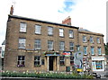
The Swan Inn, Crewkerne
One of several extensive 18th Century former coaching inns in the centre of Crewkerne. The Swan is Grade-II listed (ref. 1293297): https://www.britishlistedbuildings.co.uk/101293297-swan-inn-and-attached-stables-crewkerne#.Wj6umCZLGAg .
Image: © Bill Harrison
Taken: 11 Jul 2016
0.02 miles
7
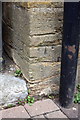
Benchmark on #16 Church Street
Ordnance Survey cut mark benchmark described on the Bench Mark Database at http://www.bench-marks.org.uk/bm56689
Image: © Roger Templeman
Taken: 30 Mar 2015
0.02 miles

9

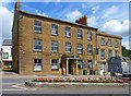
Church Street, Crewkerne
The street has some fine Georgian houses. Number 9, on the right, housed the local council offices until 1995
Image: © David Smith
Taken: 5 Jun 2014
0.02 miles
10
#16 Church Street
There is an OS benchmark Image on the right hand side of the arch, left of the downpipe
Image: © Roger Templeman
Taken: 30 Mar 2015
0.02 miles