IMAGES TAKEN NEAR TO
HINTON ST. GEORGE, TA17 8TN
Introduction
This page details the photographs taken nearby to TA17 8TN by members of the Geograph project.
The Geograph project started in 2005 with the aim of publishing, organising and preserving representative images for every square kilometre of Great Britain, Ireland and the Isle of Man.

There are currently over 7.5m images from over14,400 individuals and you can help contribute to the project by visiting https://www.geograph.org.uk
Image Map (Loading...)


Getting Data...Please wait
Leaflet Map data © OpenStreetMap
Images are licensed for reuse under creativecommons.org/licenses/by-sa/2.0
Notes
- Clicking on the map will re-center to the selected point.
- The higher the marker number, the further away the image location is from the centre of the postcode.
Image Listing (4 Images Found)
Images are licensed for reuse under creativecommons.org/licenses/by-sa/2.0
Image
Details
Distance
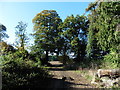
3
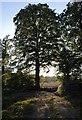
Through Harvant Wood
A glimpse of Hinton Park through trees at the edge of Harvant Wood, which here forms a narrow band of cleared woodland next to the lane passing Harford Lodge. The sunlit hedgerow tree in the distance is almost exactly on the easting gridline.
Image: © Derek Harper
Taken: 4 Sep 2007
0.15 miles
4
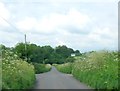
The lane to Hinton St George
The lane runs from the A30 to Hinton St George through meadows and woodland.
Image: © Sarah Smith
Taken: 27 May 2014
0.16 miles