IMAGES TAKEN NEAR TO
Church Street, MERRIOTT, TA16 5PT
Introduction
This page details the photographs taken nearby to Church Street, TA16 5PT by members of the Geograph project.
The Geograph project started in 2005 with the aim of publishing, organising and preserving representative images for every square kilometre of Great Britain, Ireland and the Isle of Man.

There are currently over 7.5m images from over14,400 individuals and you can help contribute to the project by visiting https://www.geograph.org.uk
Image Map
Images are licensed for reuse under creativecommons.org/licenses/by-sa/2.0
Notes
- Clicking on the map will re-center to the selected point.
- The higher the marker number, the further away the image location is from the centre of the postcode.
Image Listing (36 Images Found)
Images are licensed for reuse under creativecommons.org/licenses/by-sa/2.0
Image
Details
Distance
4
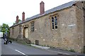
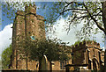
Churchyard, Merriott
Taken west of the Church of All Saints. The building in the left background is listed as the "Former Anglican Sunday school ... 1834 ... By 1861 this building used as a National Day School, then in 1875/6 became a mixed Board school, after the erection of the Infants Board school across the road: both schools were merged as Merriott First School in 1972" https://historicengland.org.uk/listing/the-list/list-entry/1308221 . It is now a cafe aimed particularly at cyclists.
Image: © Derek Harper
Taken: 27 Apr 2019
0.10 miles
5
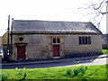
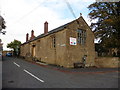
The Tithe Barn - Merriott
The Tithe Barn has been restored and acts as a village community hall. It is situated opposite the church.
Image: © Sarah Smith
Taken: 16 Mar 2009
0.10 miles
6
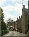
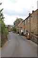
Sandy Hole, Merriott
Houses along the lane to the north of the village.
Image: © Derek Harper
Taken: 27 Apr 2019
0.11 miles
7
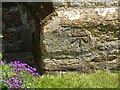
Benchmark on All Saints Church, Merriott
Ordnance Survey benchmark described on database at http://www.bench-marks.org.uk/bm66898.
Image: © Becky Williamson
Taken: 24 May 2015
0.11 miles
8
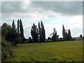
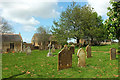
Enclosed meadow - Merriott
Looking over a gate in Church Street across the meadow towards Sherlands. The gridline cuts across the left hand corner of the field. This is some of what remains of the land which was communally farmed before 1066 in the centre of the village and is the reason for the triangular shape of the original community. Much of the land has now been built over with housing.
Image: © Sarah Smith
Taken: 13 Sep 2009
0.11 miles
9
Church of All Saints, Merriott
From Church Street. https://historicengland.org.uk/listing/the-list/list-entry/1175447 . See also http://www.geograph.org.uk/search.php?i=93527058 .
Image: © Derek Harper
Taken: 27 Apr 2019
0.12 miles
10
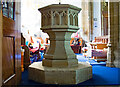
All Saints, Merriott, Somerset
The Font
Image: © Ray Jennings
Taken: 25 Jun 2013
0.12 miles