IMAGES TAKEN NEAR TO
Cornishway East, TAUNTON, TA1 5LZ
Introduction
This page details the photographs taken nearby to Cornishway East, TA1 5LZ by members of the Geograph project.
The Geograph project started in 2005 with the aim of publishing, organising and preserving representative images for every square kilometre of Great Britain, Ireland and the Isle of Man.

There are currently over 7.5m images from over14,400 individuals and you can help contribute to the project by visiting https://www.geograph.org.uk
Image Map (Loading...)


Getting Data...Please wait
Leaflet Map data © OpenStreetMap
Images are licensed for reuse under creativecommons.org/licenses/by-sa/2.0
Notes
- Clicking on the map will re-center to the selected point.
- The higher the marker number, the further away the image location is from the centre of the postcode.
Image Listing (30 Images Found)
Images are licensed for reuse under creativecommons.org/licenses/by-sa/2.0
Image
Details
Distance
1
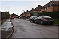
Taunton : Belmont Road
A small residential road off of Galmington Road.
Image: © Lewis Clarke
Taken: 23 Aug 2015
0.03 miles
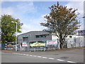
2
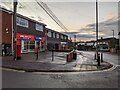
Taunton : Trident Community Centre
Trident Community Centre seen here on Galmington Road.
Image: © Lewis Clarke
Taken: 23 Aug 2015
0.07 miles
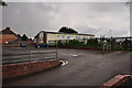
3
Warehouse, on Galmington trading estate, Taunton
Image: © Roger Cornfoot
Taken: 22 Sep 2011
0.13 miles

6

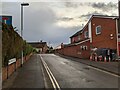
Taunton : Wellington Road
A road heading into the town centre of Taunton.
Image: © Lewis Clarke
Taken: 22 Jun 2013
0.14 miles
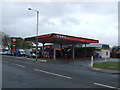
10
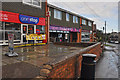
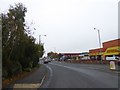
Taunton : Shops
Shops on Galmington Road including the One Stop, Honeys and Thomas Brothers Funeral Directors.
Image: © Lewis Clarke
Taken: 23 Aug 2015
0.17 miles