IMAGES TAKEN NEAR TO
Kennel Field Drive, TAUNTON, TA1 5FH
Introduction
This page details the photographs taken nearby to Kennel Field Drive, TA1 5FH by members of the Geograph project.
The Geograph project started in 2005 with the aim of publishing, organising and preserving representative images for every square kilometre of Great Britain, Ireland and the Isle of Man.

There are currently over 7.5m images from over14,400 individuals and you can help contribute to the project by visiting https://www.geograph.org.uk
Image Map
Images are licensed for reuse under creativecommons.org/licenses/by-sa/2.0
Notes
- Clicking on the map will re-center to the selected point.
- The higher the marker number, the further away the image location is from the centre of the postcode.
Image Listing (13 Images Found)
Images are licensed for reuse under creativecommons.org/licenses/by-sa/2.0
Image
Details
Distance
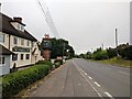
3
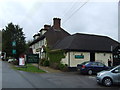
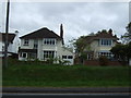
Taunton : The Stone Gallows
The Stone Gallows Pub is one of the first things you see as you enter Taunton on the A38.
Image: © Lewis Clarke
Taken: 22 Jun 2013
0.12 miles
4
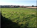
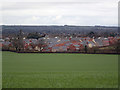
Field, Bishop's Hull
A view in a different direction across the field shown in Image, taken from the same spot.
Image: © Derek Harper
Taken: 9 Oct 2008
0.12 miles
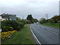
5
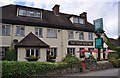
The Stonegallows pub on the edge of Taunton, on the A38
Image: © Rob Purvis
Taken: 18 Jun 2022
0.12 miles
6
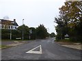
Bishops Hull Road, Bishops Hull, Taunton
Image: © David Smith
Taken: 18 Oct 2017
0.14 miles
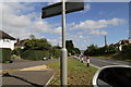
10
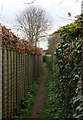
Footpath from Stonegallows to Comeytrowe
The path runs from the A38 at Stonegallows to emerge opposite the back of the crematorium.
Image: © Nick Chipchase
Taken: 30 Mar 2009
0.19 miles