IMAGES TAKEN NEAR TO
Pitts Close, TAUNTON, TA1 4TN
Introduction
This page details the photographs taken nearby to Pitts Close, TA1 4TN by members of the Geograph project.
The Geograph project started in 2005 with the aim of publishing, organising and preserving representative images for every square kilometre of Great Britain, Ireland and the Isle of Man.

There are currently over 7.5m images from over14,400 individuals and you can help contribute to the project by visiting https://www.geograph.org.uk
Image Map (Loading...)


Getting Data...Please wait
Leaflet Map data © OpenStreetMap
Images are licensed for reuse under creativecommons.org/licenses/by-sa/2.0
Notes
- Clicking on the map will re-center to the selected point.
- The higher the marker number, the further away the image location is from the centre of the postcode.
Image Listing (20 Images Found)
Images are licensed for reuse under creativecommons.org/licenses/by-sa/2.0
Image
Details
Distance
2
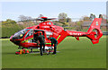
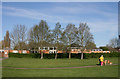
Air ambulance - Taunton
Currently the air ambulance for Musgrove Park Hospital lands in the Civil Service playing field.
Image: © Nick Chipchase
Taken: 13 Apr 2009
0.07 miles
3
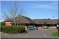
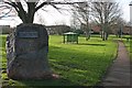
St. Michael's Church - Galmington
The original church was a concrete building in Hovelands Lane.
Image: © Nick Chipchase
Taken: 13 Apr 2009
0.07 miles
4
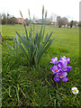
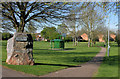
Springtime At Galmington
View across Comeytrowe playing fields from College Way.
Image: © Nick Chipchase
Taken: 5 Mar 2015
0.11 miles
9
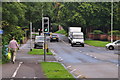
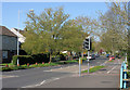
Taunton : Galmington Road
A pedestrian crossing on Galmington Road.
Image: © Lewis Clarke
Taken: 23 Aug 2015
0.18 miles
10
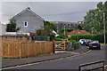
Taunton : Hoveland Crescent
Looking along Hoveland Crescent in Taunton.
Image: © Lewis Clarke
Taken: 23 Aug 2015
0.18 miles