IMAGES TAKEN NEAR TO
Haines Hill, TAUNTON, TA1 4HN
Introduction
This page details the photographs taken nearby to Haines Hill, TA1 4HN by members of the Geograph project.
The Geograph project started in 2005 with the aim of publishing, organising and preserving representative images for every square kilometre of Great Britain, Ireland and the Isle of Man.

There are currently over 7.5m images from over14,400 individuals and you can help contribute to the project by visiting https://www.geograph.org.uk
Image Map (Loading...)


Getting Data...Please wait
Leaflet Map data © OpenStreetMap
Images are licensed for reuse under creativecommons.org/licenses/by-sa/2.0
Notes
- Clicking on the map will re-center to the selected point.
- The higher the marker number, the further away the image location is from the centre of the postcode.
Image Listing (49 Images Found)
Images are licensed for reuse under creativecommons.org/licenses/by-sa/2.0
Image
Details
Distance
1
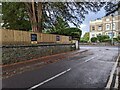
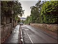
Taunton : Haines Hill
Looking along Haines Hill in the Taunton suburbs.
Image: © Lewis Clarke
Taken: 23 Aug 2015
0.02 miles
2
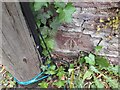
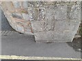
Ordnance Survey Cut Mark
This OS cut mark can be found on the wall north side of Haines Hill. It marks a point 40.883m above mean sea level.
Image: © Adrian Dust
Taken: 12 Jul 2023
0.03 miles
3
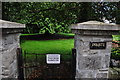
Taunton : Haines Hill Grassland
In the middle of a circular road is this private garden which is for residents only.
Image: © Lewis Clarke
Taken: 23 Aug 2015
0.05 miles
4
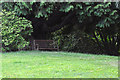
Taunton : Haines Hill Grassland
A bench in the centre of Haines Hill, but you must be a resident to use it.
Image: © Lewis Clarke
Taken: 23 Aug 2015
0.06 miles
6
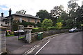
Taunton : Haines Hill
Haines Hill with a mid 19th century house - Woodville - in view.
Image: © Lewis Clarke
Taken: 23 Aug 2015
0.07 miles
7
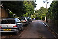
Taunton : Haines Hill
A small residential road in Taunton.
Image: © Lewis Clarke
Taken: 23 Aug 2015
0.08 miles
8
Ordnance Survey Cut Mark
This inverted OS cut mark can be found on the wall SE side of Trull Road. It marked a point 45.982m above mean sea level.
Image: © Adrian Dust
Taken: 12 Jul 2023
0.08 miles
9
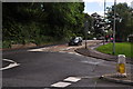
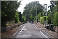
Taunton : Trull Road
Looking along Trull Road from the junction with Galmington Road.
Image: © Lewis Clarke
Taken: 23 Aug 2015
0.09 miles