IMAGES TAKEN NEAR TO
Wilton Close, TAUNTON, TA1 4EZ
Introduction
This page details the photographs taken nearby to Wilton Close, TA1 4EZ by members of the Geograph project.
The Geograph project started in 2005 with the aim of publishing, organising and preserving representative images for every square kilometre of Great Britain, Ireland and the Isle of Man.

There are currently over 7.5m images from over14,400 individuals and you can help contribute to the project by visiting https://www.geograph.org.uk
Image Map (Loading...)


Getting Data...Please wait
Leaflet Map data © OpenStreetMap
Images are licensed for reuse under creativecommons.org/licenses/by-sa/2.0
Notes
- Clicking on the map will re-center to the selected point.
- The higher the marker number, the further away the image location is from the centre of the postcode.
Image Listing (141 Images Found)
Images are licensed for reuse under creativecommons.org/licenses/by-sa/2.0
Image
Details
Distance
1
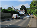
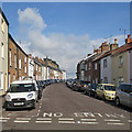
Taunton: Trull Road
A bright June morning.
Image: © John Sutton
Taken: 11 Jun 2018
0.02 miles
2
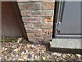
Ordnance Survey Cut Mark
This OS cut mark can be found on the wall NW of Trull Road. It marks a point 26.569m above mean sea level.
Image: © Adrian Dust
Taken: 12 Jul 2023
0.03 miles
3
Taunton: Wilton Street
Roses round the door of a house at the junction of Wilton Street (left), Wilton Grove and Burton Place.
Image: © John Sutton
Taken: 11 Jun 2018
0.05 miles
5
Taunton: Westgate Street
Looking up the hill from Burton Place on a summer morning.
Image: © John Sutton
Taken: 14 Jun 2015
0.08 miles
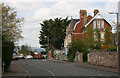
6
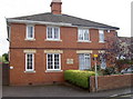
Homely station
This unassuming semi-detached was a police station in its past. See Image] for the stone.
Image: © Neil Owen
Taken: 8 Oct 2014
0.09 miles
7
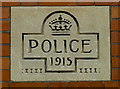
Police house
An inscribed stone tablet is all that marks an ordinary semi-detached as a former cop shop. See Image] for a look.
Image: © Neil Owen
Taken: 8 Oct 2014
0.09 miles
8
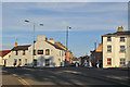
Taunton: up Compass Hill
Looking towards Westgate Street on a sunny June evening.
Image: © John Sutton
Taken: 14 Jun 2015
0.09 miles
9
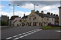
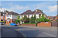
The Westgate Inn, Taunton
This pub is at the top end of Compass Hill on the corner of Westgate Street. You can see County Hall to the left of the photo, one of Taunton's Tallest Buildings.
Image: © Adrian Boliston
Taken: 28 May 2007
0.11 miles
10
Mount Nebo - Taunton
The Quantock Hills in the distance.
Image: © Nick Chipchase
Taken: 13 Apr 2009
0.11 miles