IMAGES TAKEN NEAR TO
Corporation Street, TAUNTON, TA1 4AH
Introduction
This page details the photographs taken nearby to Corporation Street, TA1 4AH by members of the Geograph project.
The Geograph project started in 2005 with the aim of publishing, organising and preserving representative images for every square kilometre of Great Britain, Ireland and the Isle of Man.

There are currently over 7.5m images from over14,400 individuals and you can help contribute to the project by visiting https://www.geograph.org.uk
Image Map (Loading...)


Getting Data...Please wait
Leaflet Map data © OpenStreetMap
Images are licensed for reuse under creativecommons.org/licenses/by-sa/2.0
Notes
- Clicking on the map will re-center to the selected point.
- The higher the marker number, the further away the image location is from the centre of the postcode.
Image Listing (679 Images Found)
Images are licensed for reuse under creativecommons.org/licenses/by-sa/2.0
Image
Details
Distance
1

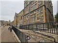
Corporation St, Taunton.
Municipal Buildings and Taxi Rank.
Image: © Nick Chipchase
Taken: 9 Mar 2009
0.00 miles
2

Ornate lamp
One of several outside the Apple and Parrot in Corporation Street.
Image: © Neil Owen
Taken: 26 May 2014
0.00 miles
3
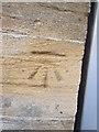
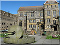
The Apple and Parrot
A prominent pub in Corporation Street; the street looks older than it actually is as it was only opened around a century ago. There used to be an institute on this site and the current pub is run by the proprietors who took it over in 2010. A benchmark lurks on the central corner - see Image
Image: © Neil Owen
Taken: 26 May 2014
0.00 miles
4
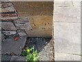
Apple and Parrot benchmark
This benchmark, on what is now a pub, is listed in the Benchmark Database: http://www.bench-marks.org.uk/bm50719 . See Image] for a wider view.
Image: © Neil Owen
Taken: 26 May 2014
0.00 miles
5
Taunton : Somerset Registration Office
The registry office in Taunton.
Image: © Lewis Clarke
Taken: 8 Sep 2021
0.01 miles
6
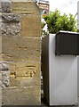
Ordnance Survey Cut Mark
This OS cut mark can be found on the Apple & Parrot. It marks a point 18.8732m above mean sea level.
Image: © Adrian Dust
Taken: 8 Feb 2015
0.01 miles
7
Ordnance Survey Cut Mark
This OS cut mark can be found on the Apple & Parrot on Corporation Street. It marks a point 18.873m above mean sea level.
Image: © Adrian Dust
Taken: 12 Jul 2023
0.01 miles
8
The millstone, Corporation Street, Taunton
The Moat House on the other side of the street.
Image: © Ken Grainger
Taken: 4 Apr 2009
0.01 miles
9
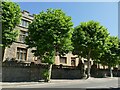
Plane trees, Corporation Street, Taunton
The plane is particularly associated with London, but other towns have planted them as street trees too. In summer leaf they hide the Old Grammar School behind, but Image shows a clearer view of the building after the trees had been pollarded.
Image: © Stephen Craven
Taken: 16 Jul 2021
0.01 miles
10
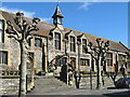
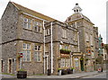
The Old Grammar School, Corporation Street, Taunton
Image: © Ken Grainger
Taken: 4 Apr 2009
0.02 miles