IMAGES TAKEN NEAR TO
North Street, STOKE-SUB-HAMDON, TA14 6TH
Introduction
This page details the photographs taken nearby to North Street, TA14 6TH by members of the Geograph project.
The Geograph project started in 2005 with the aim of publishing, organising and preserving representative images for every square kilometre of Great Britain, Ireland and the Isle of Man.

There are currently over 7.5m images from over14,400 individuals and you can help contribute to the project by visiting https://www.geograph.org.uk
Image Map (Loading...)


Getting Data...Please wait
Leaflet Map data © OpenStreetMap
Images are licensed for reuse under creativecommons.org/licenses/by-sa/2.0
Notes
- Clicking on the map will re-center to the selected point.
- The higher the marker number, the further away the image location is from the centre of the postcode.
Image Listing (48 Images Found)
Images are licensed for reuse under creativecommons.org/licenses/by-sa/2.0
Image
Details
Distance
2

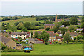
Sheep browsing in The Orchard, Chiselborough
The blossom at this time of year make the sheep look less than white.
Image: © Steve Barnes
Taken: 24 Apr 2011
0.06 miles
3

Orchard, Chiselborough
This heavily-cropping apple orchard is next to the churchyard. The village is hemmed in by many hills; the one in the background is Gawler's Hill.
Image: © Derek Harper
Taken: 15 Sep 2009
0.07 miles
4
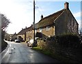
Village Street - Chiselborough
The photograph is taken on the corner of Church Lane and Cat Street. The end of the building of the Cat Head Inn is on the right.
Image: © Sarah Smith
Taken: 23 May 2009
0.08 miles
6
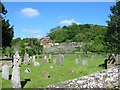
Churchyard, Chiselborough, Somerset.
Looking across the churchyard of the Church of St. Peter and St. Paul. Beyond the fence is an orchard. On this day the village was filled with the heavy scent of many flowers in the cottage gardens.
Image: © Clive Perrin
Taken: 23 May 2007
0.08 miles
8
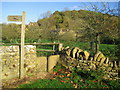
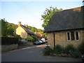
Squeeze stile - Chiselborough
This stile is located in Church Lane at the start of a footpath. Over the fence is an old apple orchard and beyond that the houses in North Lane are visible below Chiselborough Hill.
Image: © Sarah Smith
Taken: 15 Nov 2009
0.09 miles
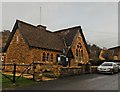
9
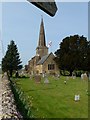
The Church of St Peter and St Paul - Chiselborough
As seen from the start of the public footpath leading to Norton Sub Hamdon and Creedy Bridge, (the bottom of the footpath sign can be seen at the top of the picture).
Image: © Steve Barnes
Taken: 24 Apr 2011
0.09 miles
10
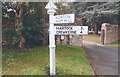
Old Direction Sign - Signpost by East Street, Chiselborough
Pyramid finial - 2 arms; Somerset SCC pyramid by the UC road, in parish of Chiselborough (South Somerset District), junction of East Street with Church Lane and North Street.
Surveyed
Milestone Society National ID: SO_ST4614B
Image: © Milestone Society
Taken: Unknown
0.09 miles