IMAGES TAKEN NEAR TO
Littlemead, STOKE-SUB-HAMDON, TA14 6SY
Introduction
This page details the photographs taken nearby to Littlemead, TA14 6SY by members of the Geograph project.
The Geograph project started in 2005 with the aim of publishing, organising and preserving representative images for every square kilometre of Great Britain, Ireland and the Isle of Man.

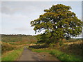
There are currently over 7.5m images from over14,400 individuals and you can help contribute to the project by visiting https://www.geograph.org.uk
Image Map (Loading...)


Getting Data...Please wait
Leaflet Map data © OpenStreetMap
Images are licensed for reuse under creativecommons.org/licenses/by-sa/2.0
Notes
- Clicking on the map will re-center to the selected point.
- The higher the marker number, the further away the image location is from the centre of the postcode.
Image Listing (75 Images Found)
Images are licensed for reuse under creativecommons.org/licenses/by-sa/2.0
Image
Details
Distance
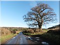
1
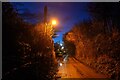
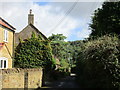
Norton sub Hamdon : Skinner's Lane
Lookin along Skinner's Lane.
Image: © Lewis Clarke
Taken: 6 Jan 2024
0.02 miles
2
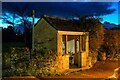
Norton sub Hamdon : Shelter
A shelter on Skinner's Lane.
Image: © Lewis Clarke
Taken: 6 Jan 2024
0.08 miles
3
Between Chiselborough and Norton sub Hamdon
This lane from Chiselborough to Norton sub Hamdon forms part of the Regional Cycle Network.
Image: © Sarah Smith
Taken: 31 Oct 2009
0.10 miles
4
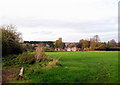
Norton sub Hamdon
A view of the village and St Mary's Church from a gateway on the Chiselborough lane.
Image: © Sarah Smith
Taken: 31 Oct 2009
0.10 miles
5
Broadmead Lane
Ham Hill in the background.
Image: © Jonathan Thacker
Taken: 14 Sep 2017
0.12 miles
6
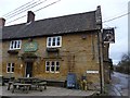
The Lord Nelson pub, Norton Sub Hamdon
There is a benchmark on this building. See
Image: © Becky Williamson
Taken: 28 Jan 2015
0.13 miles
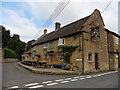
7
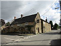
The Lord Nelson Inn, Norton sub Hamdon
Seventeenth/eighteenth century village pub https://www.britishlistedbuildings.co.uk/101241336-lord-nelson-inn-norton-sub-hamdon#.WpnOW-fLjVI
Image: © Jonathan Thacker
Taken: 14 Sep 2017
0.14 miles
8
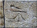
Benchmark, Lord Nelson Pub, Norton Sub Hamdon
Ordnance Survey benchmark, described on database at http://www.bench-marks.org.uk/bm63838. For view of pub, see http://www.geograph.org.uk/photo/4326398
Image: © Becky Williamson
Taken: 28 Jan 2015
0.14 miles