IMAGES TAKEN NEAR TO
Church Lane, STOKE-SUB-HAMDON, TA14 6SU
Introduction
This page details the photographs taken nearby to Church Lane, TA14 6SU by members of the Geograph project.
The Geograph project started in 2005 with the aim of publishing, organising and preserving representative images for every square kilometre of Great Britain, Ireland and the Isle of Man.

There are currently over 7.5m images from over14,400 individuals and you can help contribute to the project by visiting https://www.geograph.org.uk
Image Map (Loading...)


Getting Data...Please wait
Leaflet Map data © OpenStreetMap
Images are licensed for reuse under creativecommons.org/licenses/by-sa/2.0
Notes
- Clicking on the map will re-center to the selected point.
- The higher the marker number, the further away the image location is from the centre of the postcode.
Image Listing (83 Images Found)
Images are licensed for reuse under creativecommons.org/licenses/by-sa/2.0
Image
Details
Distance
1
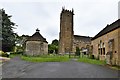
Norton Sub Hamdon, St. Mary's Church
Image: © Michael Garlick
Taken: 25 Jun 2019
0.01 miles
2
Norton Sub Hamdon, St. Mary's Church
Image: © Michael Garlick
Taken: 25 Jun 2019
0.01 miles
3
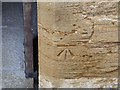
Benchmark, Church of St Mary the Virgin, Norton Sub Hamdon
Ordnance Survey benchmark, described on database at http://www.bench-marks.org.uk/bm63830. See also http://www.geograph.org.uk/photo/1563481.
Image: © Becky Williamson
Taken: 28 Jan 2015
0.01 miles
4
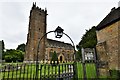
Parish church, Norton-sub-Hamdon, Somerset
dedicated to St Mary the Virgin http://www.nortonchurch.org.uk/guide1.asp ; view N from Church Lane.
Image: © Rodney Burton
Taken: 2 Mar 2006
0.01 miles
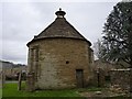
5
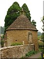
Dovecote, Norton Sub Hamdon
The listed building entry hedges its best somewhat: "possibly part of the former manor house estate. C17 or possibly earlier. Ham stone coursed rubble; stone slated conoid roof, crowned by small glover formed by circular flat slab standing on 4 slender turned stone balusters, with ball finial. Circular on plan, with 4 buttresses having offsets; low plain doorway in north side, and small dormer window with stone slate roof and checks to southwest. Interior not seen, but said to contain about 400 nesting-boxes." http://www.imagesofengland.org.uk/Details/Default.aspx?id=439972&mode=adv . More detail is supplied at http://www.pigeoncote.com/dovecote/cooke17.html
Image: © Derek Harper
Taken: 15 Sep 2009
0.01 miles
6
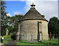
Dovecote in the churchyard, Norton sub Hamdon
Seventeenth century or earlier https://www.britishlistedbuildings.co.uk/101241076-dovecote-in-churchyard-about-15-metres-south-west-of-church-church-of-st-mary-the-virgin-norton-sub-hamdon#.WpnEJefLjVI
Image: © Jonathan Thacker
Taken: 14 Sep 2017
0.01 miles
7
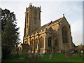
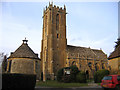
St Mary's church - Norton sub Hamdon
The church is Perpendicular with a tower of 98 feet high providing a fine example of Somerset tracery in its window lights.
Image: © Sarah Smith
Taken: 31 Oct 2009
0.01 miles
8
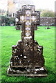
Tiled gravestone - Norton sub Hamdon
An unusual gravestone with tiles inlaid in its cross.
Image: © Sarah Smith
Taken: 31 Oct 2009
0.02 miles
9

Norton Sub Hamdon church from Ham Hill
Image: © Nick Chipchase
Taken: 5 Jun 2015
0.02 miles
10
Seventeenth Century Dovecote, Norton Sub Hamdon
Situated in the grounds of the Church of St Mary the Virgin, this dovecote was associated with a manor house which was demolished around 1850.
Image: © Becky Williamson
Taken: 28 Jan 2015
0.02 miles