IMAGES TAKEN NEAR TO
Queens Crescent, STOKE-SUB-HAMDON, TA14 6QX
Introduction
This page details the photographs taken nearby to Queens Crescent, TA14 6QX by members of the Geograph project.
The Geograph project started in 2005 with the aim of publishing, organising and preserving representative images for every square kilometre of Great Britain, Ireland and the Isle of Man.

There are currently over 7.5m images from over14,400 individuals and you can help contribute to the project by visiting https://www.geograph.org.uk
Image Map (Loading...)


Getting Data...Please wait
Leaflet Map data © OpenStreetMap
Images are licensed for reuse under creativecommons.org/licenses/by-sa/2.0
Notes
- Clicking on the map will re-center to the selected point.
- The higher the marker number, the further away the image location is from the centre of the postcode.
Image Listing (19 Images Found)
Images are licensed for reuse under creativecommons.org/licenses/by-sa/2.0
Image
Details
Distance
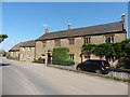
2

Dairy Cottage
This cottage stands on the corner of Whirligig Lane
Image: © Andy Pearce
Taken: 17 Oct 2008
0.16 miles
3

A well in Stoke-sub-Hamdon
This well, which is next to some allotments, has a locked grill over it for safety.
Image: © Andy Pearce
Taken: 17 Oct 2008
0.16 miles

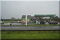
7
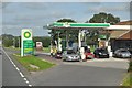
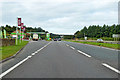
South Somerset : The A303 & BP Petrol Station
A petrol station on the A303 in South Somerset.
Image: © Lewis Clarke
Taken: 28 Aug 2012
0.18 miles
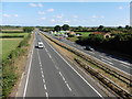
8
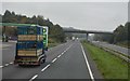
A303 heading west
This section follows the Roman Fosse Way. The service station and bridge are not original.
Image: © Robin Webster
Taken: 7 Sep 2019
0.18 miles
10
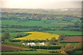
Somerset Moors: View from Ham Hill
View of Somerset towards Martock and beyond West Moor towards Langport.
Image: © Mr Eugene Birchall
Taken: 3 May 2010
0.19 miles