IMAGES TAKEN NEAR TO
North Street, STOKE-SUB-HAMDON, TA14 6QP
Introduction
This page details the photographs taken nearby to North Street, TA14 6QP by members of the Geograph project.
The Geograph project started in 2005 with the aim of publishing, organising and preserving representative images for every square kilometre of Great Britain, Ireland and the Isle of Man.

There are currently over 7.5m images from over14,400 individuals and you can help contribute to the project by visiting https://www.geograph.org.uk
Image Map
Images are licensed for reuse under creativecommons.org/licenses/by-sa/2.0
Notes
- Clicking on the map will re-center to the selected point.
- The higher the marker number, the further away the image location is from the centre of the postcode.
Image Listing (71 Images Found)
Images are licensed for reuse under creativecommons.org/licenses/by-sa/2.0
Image
Details
Distance
1
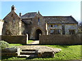
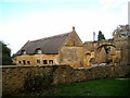
The old hall of the Priory in Stoke-sub-Hampden
Image: © Sarah Charlesworth
Taken: 12 Apr 2016
0.02 miles
2
The Priory, Stoke Sub Hamdon
Stoke sub Hamdon Priory is a complex of buildings and ruins which initially formed a 14th-century college for the chantry chapel of St Nicholas. For more information, see http://en.wikipedia.org/wiki/Stoke_sub_Hamdon_Priory.
Image: © Becky Williamson
Taken: 22 May 2015
0.02 miles
3
Gateway to Parsonage farmyard, Stoke Sub Hamdon
Image: © Bill Harrison
Taken: 7 Jul 2016
0.02 miles
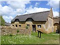
5
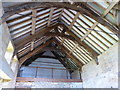
The roof of the old priory hall in Stoke-sub-Hampden
Image: © Sarah Charlesworth
Taken: 12 Apr 2016
0.02 miles
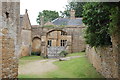
6
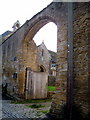
Priory gateway - Stoke sub Hamdon
Through the massive gateway one catches a glimpse of the 14th century Priest's House.
Image: © Sarah Smith
Taken: 24 Oct 2009
0.02 miles
7
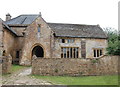
Parsonage Farmhouse (the Priory), Stoke Sub Hamdon
Originally a chantry college established in the 14th Century and Grade-I listed: http://www.britishlistedbuildings.co.uk/en-441493-parsonage-farmhouse-the-priory-stoke-sub#.V79L-iZTGmQ . The Ham stone comes from Ham Hill, just a kilometre away.
Image: © Bill Harrison
Taken: 7 Jul 2016
0.02 miles
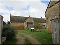
9
View from the Priest's House garden
A view of the old stables and to the right the arched gateway into the yard from North Street.
In the 16th century the whole group of buildings became a farm and the Priest's House was known as Parsonage Farmhouse.
Image: © Sarah Smith
Taken: 24 Oct 2009
0.03 miles
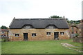
10
Barn at The Priory
Fifteenth century barn http://www.britishlistedbuildings.co.uk/101242150-barn-about-25-metres-north-west-of-the-priory-stoke-sub-hamdon#.WcbHg9FrzVI
Image: © Jonathan Thacker
Taken: 14 Sep 2017
0.03 miles