IMAGES TAKEN NEAR TO
High Street, STOKE-SUB-HAMDON, TA14 6PT
Introduction
This page details the photographs taken nearby to High Street, TA14 6PT by members of the Geograph project.
The Geograph project started in 2005 with the aim of publishing, organising and preserving representative images for every square kilometre of Great Britain, Ireland and the Isle of Man.

There are currently over 7.5m images from over14,400 individuals and you can help contribute to the project by visiting https://www.geograph.org.uk
Image Map (Loading...)


Getting Data...Please wait
Leaflet Map data © OpenStreetMap
Images are licensed for reuse under creativecommons.org/licenses/by-sa/2.0
Notes
- Clicking on the map will re-center to the selected point.
- The higher the marker number, the further away the image location is from the centre of the postcode.
Image Listing (56 Images Found)
Images are licensed for reuse under creativecommons.org/licenses/by-sa/2.0
Image
Details
Distance
1
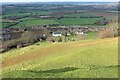
Highway, Stoke Sub Hamdon
The sunlit house is part of an area of the village named "Highway"; in shadow on the left is "Castle", which includes the site of a castle. The view is a slight variation on Image], again with the pond and fields on Rixon Common, from the same place on Ham Hill.
Image: © Derek Harper
Taken: 10 Mar 2016
0.04 miles
2
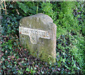
Old Milestone by the former A3088, Stoke sub Hamdon parish
Metal plates (one 'lost') attached to stone post by the UC road (was A3088), in parish of STOKE SUB HAMDON (SOUTH SOMERSET District), East Stoke, opposite No 81, 10m from entrance to Greenways, on bank under hedge beside road, on South side of road. Ilminster iron plate, erected by the Ilminster turnpike trust in the 19th century.
Inscription reads:-
: ILMINSTER / 8 : : (YEOVIL / 5½) :
Grade II listed.
List Entry Number: 1242133 https://historicengland.org.uk/listing/the-list/list-entry/1242133
Milestone Society National ID: SO_IMYV08.
Image: © Alan Rosevear
Taken: 12 Apr 2011
0.04 miles
3

Houses in Stoke Sub Hamdon
Seen from the war memorial on Ham Hill
Image: © David Smith
Taken: 5 Jun 2014
0.09 miles
4

Ham Hill Country Park: View from the War Memorial
Image: © Mr Eugene Birchall
Taken: 3 May 2010
0.10 miles
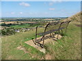
5

Stoke Sub Hamdon from the war memorial
A panorama of the Somerset plain north of Ham Hill
Image: © David Smith
Taken: 5 Jun 2014
0.12 miles
7

The war memorial on Ham Hill
The site overlooks the village of Stoke Sub Hamdon and commemorates local people
Image: © David Smith
Taken: 5 Jun 2014
0.13 miles
8
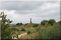
Hamdon Hill war memorial
The memorial from ca. 1923 is Grade-II listed ( http://www.britishlistedbuildings.co.uk/101241897-hamdon-hill-war-memorial-stoke-sub-hamdon#.WY7VsCaWyAg ) and sited on a hill overlooking the village of Stoke-sub-Hamden.
Image: © Bill Harrison
Taken: 8 Jul 2016
0.14 miles

10

Ham Hill Country Park: War Memorial
Picture of World War memorial taken an hour before sunset.
Image: © Mr Eugene Birchall
Taken: 3 May 2010
0.14 miles