IMAGES TAKEN NEAR TO
Orchid Acre Close, STOKE-SUB-HAMDON, TA14 6AE
Introduction
This page details the photographs taken nearby to Orchid Acre Close, TA14 6AE by members of the Geograph project.
The Geograph project started in 2005 with the aim of publishing, organising and preserving representative images for every square kilometre of Great Britain, Ireland and the Isle of Man.

There are currently over 7.5m images from over14,400 individuals and you can help contribute to the project by visiting https://www.geograph.org.uk
Image Map (Loading...)


Getting Data...Please wait
Leaflet Map data © OpenStreetMap
Images are licensed for reuse under creativecommons.org/licenses/by-sa/2.0
Notes
- Clicking on the map will re-center to the selected point.
- The higher the marker number, the further away the image location is from the centre of the postcode.
Image Listing (11 Images Found)
Images are licensed for reuse under creativecommons.org/licenses/by-sa/2.0
Image
Details
Distance
2
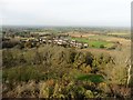
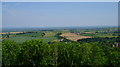
Looking down towards East Stoke
From the top of St Michaels Tower.
Image: © Roger Cornfoot
Taken: 1 Nov 2017
0.09 miles
3
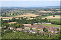
Hedgecock Hill Woods from St Michael's Hill
East Stoke Church is also visible
Image: © David Robinson
Taken: 9 Jun 2008
0.12 miles
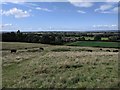
5
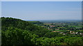
Somerset in all its glory from St Michaels Hill
Yes there were some blue skies in the summer of 2008!
Image: © David Robinson
Taken: 9 Jun 2008
0.16 miles
6
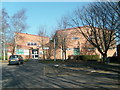
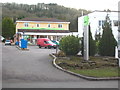
Sports Centre
The sports centre at Stanchester School.
Image: © Andy Pearce
Taken: 17 Feb 2008
0.16 miles
8
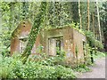
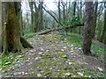
Ruined building in Hedgecock Hill Woods, Montacute
I'm not sure what this building is and have been unable to find out, so any information would be appreciated!
Image: © Becky Williamson
Taken: 22 May 2015
0.22 miles
9
Hedgecock Hill
Walked up from the Ham Hill viewpoint car park to bag this steep wooded hill with Smudge and Alex.
Name: Hedgecock Hill
Hill number: 18212
Height: 143m / 469ft
Parent (Ma/M): 2896 Lewesdon Hill
Section: 41: South Central England
County/UA: Somerset (CoU)
Class: Tump (100-199m)
Grid ref: ST489169 (est)
Drop: 62m
Col: 81m ST527112
Image: © Rude Health
Taken: 29 Mar 2015
0.22 miles
10
View looking north from the side of St Michael's Hill
Image: © Rob Purvis
Taken: 31 Aug 2019
0.24 miles