IMAGES TAKEN NEAR TO
Westmead Close, TA14 6AD
Introduction
This page details the photographs taken nearby to Westmead Close, TA14 6AD by members of the Geograph project.
The Geograph project started in 2005 with the aim of publishing, organising and preserving representative images for every square kilometre of Great Britain, Ireland and the Isle of Man.

There are currently over 7.5m images from over14,400 individuals and you can help contribute to the project by visiting https://www.geograph.org.uk
Image Map (Loading...)


Getting Data...Please wait
Leaflet Map data © OpenStreetMap
Images are licensed for reuse under creativecommons.org/licenses/by-sa/2.0
Notes
- Clicking on the map will re-center to the selected point.
- The higher the marker number, the further away the image location is from the centre of the postcode.
Image Listing (46 Images Found)
Images are licensed for reuse under creativecommons.org/licenses/by-sa/2.0
Image
Details
Distance
1

The old stables, Stoke sub Hamdon Priory
Image: © Ken Grainger
Taken: 1 Jul 2009
0.09 miles
3
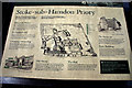
Site Plan - The Priory - Stoke Sub Hamdon
Image: © Mike Searle
Taken: 24 Jul 2008
0.09 miles
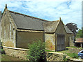
4

The Priory - Stoke Sub Hamdon (5)
The C15 barn.
Image: © Mike Searle
Taken: 24 Jul 2008
0.10 miles
5

The Priory - Stoke Sub Hamdon
It has been known by several names, The Priory being one, Parsonage Farmhouse or Chantry House were others; originally the College Buildings of the Beauchamp Chantry, it's now a private house. Built of local Ham stone like so many of the old buildings around here, it dates from the C14, although the roadside frontage is C17. This surviving part of the college was apparently the Provost's Lodging, after 1518, it became a farm, remaining so until c.1960. After major restorations in 1967, the house became the property of the National Trust, and Grade I Listed.
Image: © Mike Searle
Taken: 24 Jul 2008
0.10 miles
7

The Priory - Stoke Sub Hamdon (3)
Inside the site occupied by the complex of buildings known as The Priory is a stable on the left, and just beyond that is the gateway entrance that was primarily for carts. Further to the right is the medieval Hall that would have been used for communal sleeping and eating, and to the left of that is the Priory House and the attached chapel. The buildings were once the residence of the Provost and fellow chaplains of the Beauchamp Chantry Foundation. The Beauchamps were a family of some note in the West from the late C12 until the late C14, and held properties directly from the King. Sadly the chantry itself no longer exists, and apart from the Hall, what remains are largely medieval farm buildings.
Image: © Mike Searle
Taken: 24 Jul 2008
0.11 miles
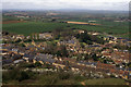
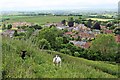
8

Looking down on Stoke Sub Hamdon, from Ham Hill
Image: © Roger Cornfoot
Taken: 14 Sep 2016
0.11 miles
9
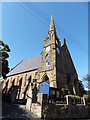
United Reformed Church, Stoke Sub Hamdon
Image: © Roger Cornfoot
Taken: 14 Sep 2016
0.11 miles