IMAGES TAKEN NEAR TO
Fons George Close, TAUNTON, TA1 3SG
Introduction
This page details the photographs taken nearby to Fons George Close, TA1 3SG by members of the Geograph project.
The Geograph project started in 2005 with the aim of publishing, organising and preserving representative images for every square kilometre of Great Britain, Ireland and the Isle of Man.

There are currently over 7.5m images from over14,400 individuals and you can help contribute to the project by visiting https://www.geograph.org.uk
Image Map
Images are licensed for reuse under creativecommons.org/licenses/by-sa/2.0
Notes
- Clicking on the map will re-center to the selected point.
- The higher the marker number, the further away the image location is from the centre of the postcode.
Image Listing (82 Images Found)
Images are licensed for reuse under creativecommons.org/licenses/by-sa/2.0
Image
Details
Distance
1
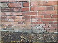
Ordnance Survey Cut Mark
This OS cut mark can be found on a building SW side of Fons George. It marks a point 22.561m above mean sea level.
Image: © Adrian Dust
Taken: 12 Jul 2023
0.06 miles
2
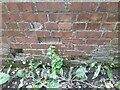
Ordnance Survey Cut Mark
This OS cut mark can be found on a garage west side of Fons George. It marks a point 22.914m above mean sea level.
Image: © Adrian Dust
Taken: 12 Jul 2023
0.06 miles
3
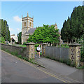
Wilton: St George
The Grade II* listing text begins "The outside is mostly Victorian, but a little long-and-short work in the west wall south of the tower is evidence that the west end of the nave incorporates some remains of a Saxon chapel. The tower was completely rebuilt in 1853, on the model of smaller Perp village churches in Somerset: of two stages, with diagonal buttresses, embattled parapet and two-light bell openings". The road is narrow and winding, so the church path is a safe route for pedestrians.
Image: © John Sutton
Taken: 11 Jun 2018
0.08 miles
4
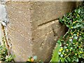
Ordnance Survey Cut Mark
This OS cut mark can be found on the south angle of St George's Church. It marks a point 26.220m above mean sea level.
Image: © Adrian Dust
Taken: 12 Jul 2023
0.08 miles
5
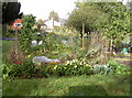
Wilton Church allotments
Fertile ground next to the holy ground of St George's church.
Image: © Neil Owen
Taken: 8 Oct 2014
0.08 miles
6
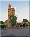
Wilton: St George - tower and lychgate
A largely Victorian church in a village which is now part of Taunton, lit by the setting sun on a fine June evening.
Image: © John Sutton
Taken: 10 Jun 2018
0.08 miles
7
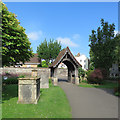
Wilton: churchyard and lychgate
The Grade II* listed St George's Church is largely Victorian, though Saxon in origin.
Image: © John Sutton
Taken: 11 Jun 2018
0.08 miles
8
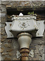
Rose water
An interesting motif on the guttering of St George's church.
Image: © Neil Owen
Taken: 8 Oct 2014
0.09 miles
9
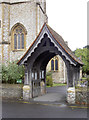
St George's lych gate
Entrance to the old church with its Victorian tower. See Image] for a better look at the tower.
Image: © Neil Owen
Taken: 8 Oct 2014
0.09 miles
10
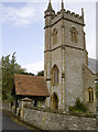
St George in Wilton
There has been an important church on this site since Saxon times; indeed, some of the stone work dates back to that time, despite having the Normans and the eager Victorians make a number of additions and alterations. The area of Wilton derives from its watercourses that provided for the locals - 'Well Tun'. See Image] for a benchmark or Image] for a better look at the lych gate.
Image: © Neil Owen
Taken: 8 Oct 2014
0.09 miles