IMAGES TAKEN NEAR TO
East Street, TAUNTON, TA1 3LS
Introduction
This page details the photographs taken nearby to East Street, TA1 3LS by members of the Geograph project.
The Geograph project started in 2005 with the aim of publishing, organising and preserving representative images for every square kilometre of Great Britain, Ireland and the Isle of Man.

There are currently over 7.5m images from over14,400 individuals and you can help contribute to the project by visiting https://www.geograph.org.uk
Image Map
Images are licensed for reuse under creativecommons.org/licenses/by-sa/2.0
Notes
- Clicking on the map will re-center to the selected point.
- The higher the marker number, the further away the image location is from the centre of the postcode.
Image Listing (404 Images Found)
Images are licensed for reuse under creativecommons.org/licenses/by-sa/2.0
Image
Details
Distance
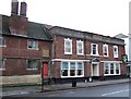
1
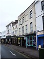
East Gate, Taunton
These buildings are roughly on the site of the East Gate, at the east end of East Street, and described at http://webapp1.somerset.gov.uk/her/details.asp?prn=44461 . For a description of the Old Council House, see http://webapp1.somerset.gov.uk/her/details.asp?prn=45978 . The nearer buildings, dating from the early C19 are described at http://webapp1.somerset.gov.uk/her/details.asp?prn=45980 . They are virtually opposite the junction with Silver Street.
Image: © Derek Harper
Taken: 10 Jan 2008
0.01 miles
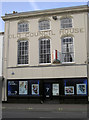
4

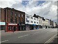
Taunton : Primark
A Primark clothing outlet on East Street
Image: © Lewis Clarke
Taken: 19 Dec 2005
0.01 miles
5
Almshouses- Eastgate.
Popes and Grays Almshouses.Shops and public pump centre.
Image: © Unknown
Taken: 30 Apr 1908
0.01 miles
6
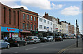
The Old Council House
A blank canvas lends weight to the ideal that this particular property may be due for a change of use. Originally it was the Offices of the Local Board of Health, but what it will be in the future is more likely to be retail.
Image: © Neil Owen
Taken: 30 Oct 2014
0.02 miles
7
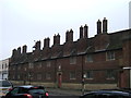
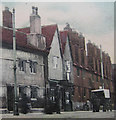
Gray's Almshouses
These almshouses were built in 1635 and renovated in 1990. They still provide sheltered accommodation for older people in Taunton.
Image: © Ruth Riddle
Taken: 18 Feb 2011
0.02 miles
8
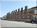
Gray's Almshouses, East Street, Taunton
These town centre almshouses are grade I listed (entry 1232341). The listing dates them to 1635 but says the foundation of almshouses in the town dates was with Robert Gray in 1015, which if correct would make it one of the earliest such foundations in the country (the website almshouses.org dates the earliest to 990).
Image: © Stephen Craven
Taken: 16 Jul 2021
0.02 miles
9
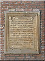
Gray's Almshouses, East Street, Taunton - datestone
The stone tablet explains the foundation of the almshouses by Robert Graye (though the more modern spelling Gray is usually used to refer to them these days) and gives the date 1635. See Image for context.
Image: © Stephen Craven
Taken: 16 Jul 2021
0.02 miles
10
Remedies Bar, Taunton
On the left of this C18 building (described at http://webapp1.somerset.gov.uk/her/details.asp?prn=45982 ) is the western end of the facade of Image "Remedies" is shown as a pub on the 1:1250 map, but I cannot trace a former name.
Image: © Derek Harper
Taken: 10 Jan 2008
0.03 miles