IMAGES TAKEN NEAR TO
Wilton Street, TAUNTON, TA1 3JR
Introduction
This page details the photographs taken nearby to Wilton Street, TA1 3JR by members of the Geograph project.
The Geograph project started in 2005 with the aim of publishing, organising and preserving representative images for every square kilometre of Great Britain, Ireland and the Isle of Man.

There are currently over 7.5m images from over14,400 individuals and you can help contribute to the project by visiting https://www.geograph.org.uk
Image Map (Loading...)


Getting Data...Please wait
Leaflet Map data © OpenStreetMap
Images are licensed for reuse under creativecommons.org/licenses/by-sa/2.0
Notes
- Clicking on the map will re-center to the selected point.
- The higher the marker number, the further away the image location is from the centre of the postcode.
Image Listing (138 Images Found)
Images are licensed for reuse under creativecommons.org/licenses/by-sa/2.0
Image
Details
Distance
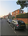
1
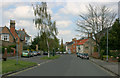
Middleway - Taunton
St Johns church in the distance.Vivary Arms inn - right.
Image: © Nick Chipchase
Taken: 13 Apr 2009
0.03 miles
2
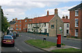
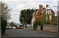
Wilton: The Vivary Arms
At the corner of Wilton Street (ahead) and Fons George. Middleway is behind the camera.
Image: © John Sutton
Taken: 11 Jun 2018
0.03 miles
4
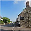
The Vivary Arms
Originally in the Wilton district, the growing reach of Taunton now embraces this oldest of pubs. A benchmark can be seen on the side wall where the light coloured paint begins - see .
Image: © Neil Owen
Taken: 8 Oct 2014
0.04 miles
5
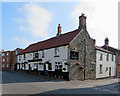
The Vivary Arms, Wilton Street
Probably dating from the 18th century, the former New Inn is Grade II listed.
Image: © John Sutton
Taken: 11 Jun 2018
0.04 miles
6
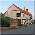
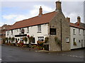
Wilton: The Vivary Arms on a June evening
The former New Inn is Grade II listed.
Image: © John Sutton
Taken: 10 Jun 2018
0.04 miles
7
Wilton: Middleway on a June evening
The Vivary Arms and the three-storey house The Orchard are Grade II listed.
Image: © John Sutton
Taken: 10 Jun 2018
0.05 miles
8
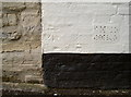
Fons George benchmark
A cutmark on the side of the Vivary Arms in Fons George - the road that leads to St George church. See http://www.bench-marks.org.uk/bm62012 for the entry in the Benchmark Database.
Image: © Neil Owen
Taken: 8 Oct 2014
0.05 miles
9
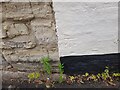
Ordnance Survey Cut Mark
This OS cut mark can be found on the Vivary Arms. It marks a point 29.672m above mean sea level.
Image: © Adrian Dust
Taken: 12 Jul 2023
0.05 miles
10
Mount Nebo - Taunton
The Quantock Hills in the distance.
Image: © Nick Chipchase
Taken: 13 Apr 2009
0.05 miles