IMAGES TAKEN NEAR TO
Mitre Court, TAUNTON, TA1 3ER
Introduction
This page details the photographs taken nearby to Mitre Court, TA1 3ER by members of the Geograph project.
The Geograph project started in 2005 with the aim of publishing, organising and preserving representative images for every square kilometre of Great Britain, Ireland and the Isle of Man.

There are currently over 7.5m images from over14,400 individuals and you can help contribute to the project by visiting https://www.geograph.org.uk
Image Map
Images are licensed for reuse under creativecommons.org/licenses/by-sa/2.0
Notes
- Clicking on the map will re-center to the selected point.
- The higher the marker number, the further away the image location is from the centre of the postcode.
Image Listing (71 Images Found)
Images are licensed for reuse under creativecommons.org/licenses/by-sa/2.0
Image
Details
Distance
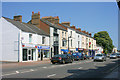
2
White Hart Inn - Taunton
Also shops in East Reach.
Image: © Nick Chipchase
Taken: 11 May 2009
0.07 miles
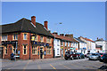
3
Victoria Gate public house, Taunton
Another pub I haven't actually been in. I like photographing (and drinking in) public houses but will usually not take a picture if there are people stood outside smoking and drinking.
Image: © Chris Allen
Taken: 4 Dec 2018
0.07 miles
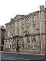
4
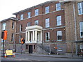
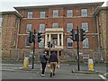
The Taunton and Somerset Hospital
This particular hospital was supported by free contributions from the town and founded in 1809 by Dr. Malachi Blake, finally opening in 1812 in George III's Golden Jubilee. It was primarily used as a nurses' training centre and closed in 1986.
Image: © Neil Owen
Taken: 30 Oct 2014
0.11 miles
5
Taunton : East Reach House
East Reach House is now the Taunton Family Hub for people like myself to take our child for some speech and language therapy or, on other occasions, physiotherapy.
Image: © Lewis Clarke
Taken: 16 Dec 2024
0.11 miles
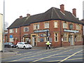
6
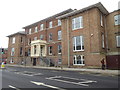
Former Taunton & Somerset Hospital
Supported by free contributions is proclaimed on the frontage. I always like to photograph current and former hospitals - bit of a busman's holiday. It was a challenge to get a traffic free shot.
Image: © Chris Allen
Taken: 4 Dec 2018
0.11 miles
7
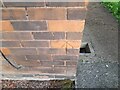
Ordnance Survey Cut Mark
This OS cut mark can be found on No 9 Leycroft Road. It marks a point 16.302m above mean sea level.
Image: © Adrian Dust
Taken: 12 Jul 2023
0.12 miles
8
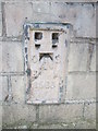
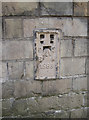
Ordnance Survey Flush Bracket (1583)
This OS Flush Bracket can be found on the old County Hospital building. It marks a point 16.0688m above mean sea level.
Image: © Adrian Dust
Taken: 8 Feb 2015
0.12 miles
9
Hospital Institute flush bracket
A paint-covered benchmark on the old Victoria Jubilee Nursing Institute in East Reach. See Image] for a wider view and http://www.bench-marks.org.uk/bm10529 for the entry in the Benchmark Database.
Image: © Neil Owen
Taken: 30 Oct 2014
0.12 miles
10
Victoria Jubilee Nursing Institute
Part of a former hospital in Taunton. Getting a car free shot was quite a wait.
Image: © Chris Allen
Taken: 4 Dec 2018
0.13 miles