IMAGES TAKEN NEAR TO
Over Stratton, SOUTH PETHERTON, TA13 5LL
Introduction
This page details the photographs taken nearby to TA13 5LL by members of the Geograph project.
The Geograph project started in 2005 with the aim of publishing, organising and preserving representative images for every square kilometre of Great Britain, Ireland and the Isle of Man.

There are currently over 7.5m images from over14,400 individuals and you can help contribute to the project by visiting https://www.geograph.org.uk
Image Map (Loading...)


Getting Data...Please wait
Leaflet Map data © OpenStreetMap
Images are licensed for reuse under creativecommons.org/licenses/by-sa/2.0
Notes
- Clicking on the map will re-center to the selected point.
- The higher the marker number, the further away the image location is from the centre of the postcode.
Image Listing (7 Images Found)
Images are licensed for reuse under creativecommons.org/licenses/by-sa/2.0
Image
Details
Distance
1
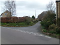
"Fosse Way" Junction
The road from left to right is the main street of Over Stratton.
The lane straight ahead goes to Yeabridge and is part of the old
Fosse Way.
Image: © Andy Pearce
Taken: 2 Mar 2008
0.07 miles
3
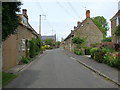
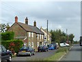
Over Stratton
The small village of Over Stratton showing the Royal Oak pub on the right of the photo.
Image: © Liz Martin
Taken: 16 May 2005
0.13 miles
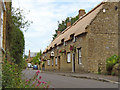
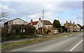
5
Cottages in Watergore
The main road through the village has been realigned, so these houses do not front onto the through route any longer.
Image: © David Smith
Taken: 2 Oct 2014
0.20 miles
6
Houses on Harp Road, Watergore, Somerset
Image: © nick macneill
Taken: 9 Mar 2013
0.21 miles
7

Esso service station, South Petherton
Image: © Roger Cornfoot
Taken: 26 Oct 2016
0.23 miles