IMAGES TAKEN NEAR TO
Broomhill Lane, SOUTH PETHERTON, TA13 5LA
Introduction
This page details the photographs taken nearby to Broomhill Lane, TA13 5LA by members of the Geograph project.
The Geograph project started in 2005 with the aim of publishing, organising and preserving representative images for every square kilometre of Great Britain, Ireland and the Isle of Man.

There are currently over 7.5m images from over14,400 individuals and you can help contribute to the project by visiting https://www.geograph.org.uk
Image Map (Loading...)


Getting Data...Please wait
Leaflet Map data © OpenStreetMap
Images are licensed for reuse under creativecommons.org/licenses/by-sa/2.0
Notes
- Clicking on the map will re-center to the selected point.
- The higher the marker number, the further away the image location is from the centre of the postcode.
Image Listing (14 Images Found)
Images are licensed for reuse under creativecommons.org/licenses/by-sa/2.0
Image
Details
Distance
1
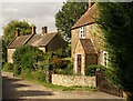
Cottages at Broomhill
The pair of stone cottages, and Sunnyhill Farm, are on Lopen Lane, which here runs along the line of the historic Fosse Way.
Image: © Derek Harper
Taken: 15 Sep 2009
0.02 miles

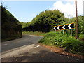

6

Junction on the Fosse Way
The line of the Fosse is to the left, followed by Lopen Lane. Higgin's Grave Lane, to the right, climbs to the former A303 at Lopen Head Nursery.
Image: © Derek Harper
Taken: 15 Sep 2009
0.17 miles
7
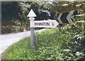
Direction Sign - Signpost north of Lopen
Pyramid finial - 1 arm; Somerset SCC pyramid by the UC road, in parish of Lopen (South Somerset District), on the southwest side of the T junction of Snapant and Holloway.
surveyed
Milestone Society National ID: SO_ST4214
Image: © Milestone Society
Taken: Unknown
0.19 miles
8

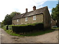
Fork in the Ways
Although this is a little used track the road on the left was once one of the most important roads in the country, the Fosse Way. The other is Higgin's Grave Lane and they combine to form Lopen Lane. (Behind the photographer)
Image: © Nigel Mykura
Taken: 19 Feb 2016
0.19 miles
9

West Orchard caravan and camping site
Image: © Jonathan Thacker
Taken: 15 Sep 2017
0.19 miles
10

New industrial building, Lopen Head
Presumably in an attempt to avoid the monotony of a metal-faced building, this has brick cladding on parts of the wall
Image: © David Smith
Taken: 2 Oct 2014
0.19 miles