IMAGES TAKEN NEAR TO
Harp Road, SOUTH PETHERTON, TA13 5JG
Introduction
This page details the photographs taken nearby to Harp Road, TA13 5JG by members of the Geograph project.
The Geograph project started in 2005 with the aim of publishing, organising and preserving representative images for every square kilometre of Great Britain, Ireland and the Isle of Man.

There are currently over 7.5m images from over14,400 individuals and you can help contribute to the project by visiting https://www.geograph.org.uk
Image Map
Images are licensed for reuse under creativecommons.org/licenses/by-sa/2.0
Notes
- Clicking on the map will re-center to the selected point.
- The higher the marker number, the further away the image location is from the centre of the postcode.
Image Listing (26 Images Found)
Images are licensed for reuse under creativecommons.org/licenses/by-sa/2.0
Image
Details
Distance
1

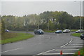
Esso service station, South Petherton
Image: © Roger Cornfoot
Taken: 26 Oct 2016
0.08 miles
3
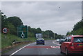
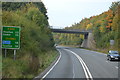
A303 approaching a roundabout, South Petherton
Image: © N Chadwick
Taken: 8 Jun 2012
0.08 miles

7
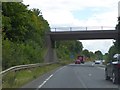
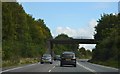
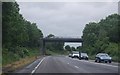
Minor road crossing A303 at Watergore
The road also carries the River Parrett Trail, a named path. The minor roads here were extensively realigned when this section of A303 was built, so only one bridge was needed
Image: © David Smith
Taken: 14 Aug 2014
0.15 miles