IMAGES TAKEN NEAR TO
SOUTH PETHERTON, TA13 5HR
Introduction
This page details the photographs taken nearby to TA13 5HR by members of the Geograph project.
The Geograph project started in 2005 with the aim of publishing, organising and preserving representative images for every square kilometre of Great Britain, Ireland and the Isle of Man.

There are currently over 7.5m images from over14,400 individuals and you can help contribute to the project by visiting https://www.geograph.org.uk
Image Map (Loading...)


Getting Data...Please wait
Leaflet Map data © OpenStreetMap
Images are licensed for reuse under creativecommons.org/licenses/by-sa/2.0
Notes
- Clicking on the map will re-center to the selected point.
- The higher the marker number, the further away the image location is from the centre of the postcode.
Image Listing (15 Images Found)
Images are licensed for reuse under creativecommons.org/licenses/by-sa/2.0
Image
Details
Distance
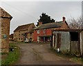
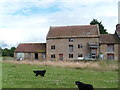
2
Buildings at Joylers Mill
The main mill building is out of image to the left. Part of the redbrick mill-house can be seen.
Image: © Nigel Mykura
Taken: 12 Nov 2016
0.01 miles
3
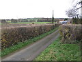
Lane to Joylers Mill
In the Parrott valley between South Petherton and Martock.
Image: © Jonathan Billinger
Taken: 28 Nov 2007
0.03 miles
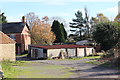
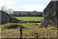
5
Joyler's Mill, South Petherton
The mill looks a bit dilapidated these days.
The present buildings are 19th century but
there is documentary evidence of an extensive
mill complex here in the 14th century.
Image: © Andy Pearce
Taken: 16 Jul 2008
0.04 miles
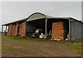
6
South Petherton Community Hospital
In the distance is the main hospital building . In the foreground are some of the buildings at the farm at Joyler's Mill close to the River Parrett.
Image: © Nigel Mykura
Taken: 12 Nov 2016
0.05 miles
7
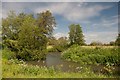
Bend in the River Parrett near Joylers Mill
Image: © Becky Williamson
Taken: 27 May 2015
0.10 miles
8

Amber snail
On an evening stroll by the river Parrett
Image: © Pam Goodey
Taken: 29 Apr 2007
0.14 miles
9
View from Cripple Hill
View looking toward the River Parrett which flows amongst the
trees in the centre of the photograph. The buildings just visible
on top of the rising ground in the background are houses at
Stoodham in South Petherton.
Image: © Andy Pearce
Taken: 21 Jul 2008
0.15 miles
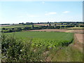
10
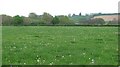
Parrett flood plain
Grassland on the edge of South Petherton.
Image: © Richard Webb
Taken: 20 Apr 2011
0.20 miles