IMAGES TAKEN NEAR TO
East Lambrook Road, SOUTH PETHERTON, TA13 5HP
Introduction
This page details the photographs taken nearby to East Lambrook Road, TA13 5HP by members of the Geograph project.
The Geograph project started in 2005 with the aim of publishing, organising and preserving representative images for every square kilometre of Great Britain, Ireland and the Isle of Man.

There are currently over 7.5m images from over14,400 individuals and you can help contribute to the project by visiting https://www.geograph.org.uk
Image Map (Loading...)


Getting Data...Please wait
Leaflet Map data © OpenStreetMap
Images are licensed for reuse under creativecommons.org/licenses/by-sa/2.0
Notes
- Clicking on the map will re-center to the selected point.
- The higher the marker number, the further away the image location is from the centre of the postcode.
Image Listing (4 Images Found)
Images are licensed for reuse under creativecommons.org/licenses/by-sa/2.0
Image
Details
Distance
1
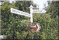
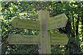
Direction Sign - Signpost at Atkin's Gate, South Petherton
Pyramid finial - 3 arms; Somerset SCC pyramid by the UC road, in parish of South Petherton (South Somerset District), at Atkin's Gate on the north side of the Y junction of East Lambrook Road and Pitway Hill.
surveyed
Milestone Society National ID: SO_ST4317C
Image: © Milestone Society
Taken: Unknown
0.17 miles
3
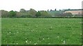
Parrett flood plain
Grassland on the edge of South Petherton.
Image: © Richard Webb
Taken: 20 Apr 2011
0.19 miles