IMAGES TAKEN NEAR TO
SOUTH PETHERTON, TA13 5HB
Introduction
This page details the photographs taken nearby to TA13 5HB by members of the Geograph project.
The Geograph project started in 2005 with the aim of publishing, organising and preserving representative images for every square kilometre of Great Britain, Ireland and the Isle of Man.

There are currently over 7.5m images from over14,400 individuals and you can help contribute to the project by visiting https://www.geograph.org.uk
Image Map (Loading...)


Getting Data...Please wait
Leaflet Map data © OpenStreetMap
Images are licensed for reuse under creativecommons.org/licenses/by-sa/2.0
Notes
- Clicking on the map will re-center to the selected point.
- The higher the marker number, the further away the image location is from the centre of the postcode.
Image Listing (4 Images Found)
Images are licensed for reuse under creativecommons.org/licenses/by-sa/2.0
Image
Details
Distance
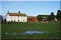
2
Lake Farm and scenery from the south
Image: © Nick Chipchase
Taken: 11 Jan 2013
0.06 miles
3
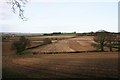
Lake Farm and farm land from the south
Image: © Nick Chipchase
Taken: 11 Jan 2013
0.08 miles
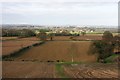
4
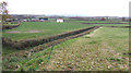
Iron Dish Lane
Deeply indented into the landscape, this dead-end lane leads to Lake Farm. This distant view is towards part of the Sedgemoor of Somerset.
Image: © Jonathan Billinger
Taken: 28 Nov 2007
0.21 miles