IMAGES TAKEN NEAR TO
West Lambrook, SOUTH PETHERTON, TA13 5HA
Introduction
This page details the photographs taken nearby to TA13 5HA by members of the Geograph project.
The Geograph project started in 2005 with the aim of publishing, organising and preserving representative images for every square kilometre of Great Britain, Ireland and the Isle of Man.

There are currently over 7.5m images from over14,400 individuals and you can help contribute to the project by visiting https://www.geograph.org.uk
Image Map (Loading...)


Getting Data...Please wait
Leaflet Map data © OpenStreetMap
Images are licensed for reuse under creativecommons.org/licenses/by-sa/2.0
Notes
- Clicking on the map will re-center to the selected point.
- The higher the marker number, the further away the image location is from the centre of the postcode.
Image Listing (9 Images Found)
Images are licensed for reuse under creativecommons.org/licenses/by-sa/2.0
Image
Details
Distance
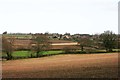
2
View over West Lambrook, Somerset
– looking from the NE with blackcurrant rows in the foreground.
Image: © Rodney Burton
Taken: 27 Feb 2006
0.03 miles
4
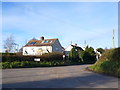
Road Junction at West Lambrook
This is the junction at the south end of this small village. The left hand road goes to Shepton Beauchamp and the one in the foreground to Compton Durville. The houses are the first in the village as one approaches from the south.
Image: © Nigel Mykura
Taken: 29 Nov 2012
0.10 miles
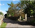
5
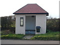
Bus Shelter at West Lambrook
The shelter was built after the second world war
as a thanks offering for the safe return of all
the local people who served in the war.
Image: © Andy Pearce
Taken: 4 Feb 2008
0.11 miles
6
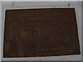
Memorial Plaque in the Bus Shelter at West Lambrook
Image: © Andy Pearce
Taken: 4 Feb 2008
0.11 miles
7
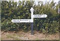
Old Direction Sign - Signpost, Lambrook Gate, West Lambrook
Pyramid finial - 2 arms; Somerset SCC pyramid (Sheldon) by the UC road, in parish of South Petherton (South Somerset District), Lambrook Gate, West Lambrook, junction of Lambrook Road and Shapway.
Surveyed
Milestone Society National ID: SO_ST4118A.
Image: © Milestone Society
Taken: Unknown
0.12 miles
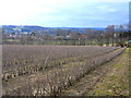
8
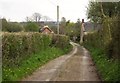
West Lane
The lane approaching West Lambrook, with Greenway Farm on the right. Left of centre is Brierly Cottage, formerly two dwellings http://webapp1.somerset.gov.uk/her/details.asp?prn=22469 .
Image: © Derek Harper
Taken: 27 Apr 2013
0.13 miles
9
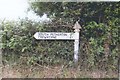
Old Direction Sign - Signpost by Shapway, West Lambrook
Pyramid finial - 1 arm; Somerset SCC pyramid by the UC road, in parish of South Petherton (South Somerset District), Lambrook Gate, West Lambrook, junction of Lambrook Road with Shapway.
Surveyed
Milestone Society National ID: SO_ST4118B
Image: © Milestone Society
Taken: Unknown
0.13 miles