IMAGES TAKEN NEAR TO
West Street, SOUTH PETHERTON, TA13 5DQ
Introduction
This page details the photographs taken nearby to West Street, TA13 5DQ by members of the Geograph project.
The Geograph project started in 2005 with the aim of publishing, organising and preserving representative images for every square kilometre of Great Britain, Ireland and the Isle of Man.

There are currently over 7.5m images from over14,400 individuals and you can help contribute to the project by visiting https://www.geograph.org.uk
Image Map (Loading...)


Getting Data...Please wait
Leaflet Map data © OpenStreetMap
Images are licensed for reuse under creativecommons.org/licenses/by-sa/2.0
Notes
- Clicking on the map will re-center to the selected point.
- The higher the marker number, the further away the image location is from the centre of the postcode.
Image Listing (156 Images Found)
Images are licensed for reuse under creativecommons.org/licenses/by-sa/2.0
Image
Details
Distance
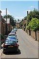
2
Churchyard and The Surgery, South Petherton
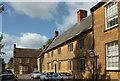
Looking more to the left than Image], and taken an hour earlier, with the sun catching the gable of The Surgery https://historicengland.org.uk/listing/the-list/list-entry/1345915 : "Earlier C18, some late C18 and C19 modifications." On the right is Monks Corner https://historicengland.org.uk/listing/the-list/list-entry/1345916 . In the foreground is the Hebditch monument https://historicengland.org.uk/listing/the-list/list-entry/1188238 .
Image: © Derek Harper
Taken: 27 Apr 2019
0.03 miles
3
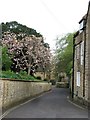
Hele Lane
Running past the church in South Petherton.
Image: © Richard Webb
Taken: 20 Apr 2011
0.03 miles
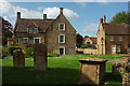
4
Churchyard, South Petherton
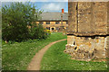
With gravestones and the "first World War Memorial, up 8 steps, in the form of a churchyard cross on an octagonal base of 3 steps" https://historicengland.org.uk/listing/the-list/list-entry/1056924 . Everything seems to be created in Ham stone. The chest tomb on the right is the Hebditch monument https://historicengland.org.uk/listing/the-list/list-entry/1188238 . In the centre background is the C18 Monks Corner https://historicengland.org.uk/listing/the-list/list-entry/1345916 ; on the right is the grade II* listed C17 Under-Sheriff's Office https://historicengland.org.uk/listing/the-list/list-entry/1056926 , with mullions. On the extreme left is a glimpse of The Surgery https://historicengland.org.uk/listing/the-list/list-entry/1345915 .
Image: © Derek Harper
Taken: 27 Apr 2019
0.04 miles
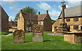
5
Church Parade, South Petherton
Dominating the row opposite the churchyard is the grade II* listed C17 Under-Sheriff's Office https://historicengland.org.uk/listing/the-list/list-entry/1056926 . Beyond it is the C18 Monks Corner https://historicengland.org.uk/listing/the-list/list-entry/1345916 .
Image: © Derek Harper
Taken: 27 Apr 2019
0.04 miles
6
Churchyard, South Petherton
Looking round the southwest corner of the grade I listed church https://historicengland.org.uk/listing/the-list/list-entry/1056959 . Beyond the war memorial cross is the grade II* listed C17 Under-Sheriff's Office https://historicengland.org.uk/listing/the-list/list-entry/1056926 .
Image: © Derek Harper
Taken: 27 Apr 2019
0.04 miles
7
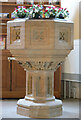
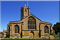
St. Peter and St. Paul, South Petherton, Somerset
The Font
Image: © Ray Jennings
Taken: 17 Jun 2010
0.04 miles
8
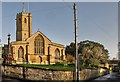
South Petherton: Church of St Peter and St Paul
Of Saxon origins the Church retains a 13th century crosswing, with the remainder of the buildings dating from the 15th century. It later underwent major restorations in the late 19th and early 20th centuries.
Image: © Mr Eugene Birchall
Taken: 3 Jan 2016
0.05 miles
9
St. Peter and St. Paul, South Petherton, Somerset
Western elevation
Image: © Ray Jennings
Taken: 17 Jun 2010
0.05 miles
10
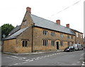
'Under Sheriff's Office' South Petherton
A fine Ham stone building from the late 17th Century and Grade II* listed: http://www.britishlistedbuildings.co.uk/101056926-under-sheriffs-office-south-petherton#.WYS_kyaWyAg . The height of the gable-end above the slate roof suggests that it was once thatched.
Image: © Bill Harrison
Taken: 15 Jul 2016
0.05 miles