IMAGES TAKEN NEAR TO
Silver Street, SOUTH PETHERTON, TA13 5BY
Introduction
This page details the photographs taken nearby to Silver Street, TA13 5BY by members of the Geograph project.
The Geograph project started in 2005 with the aim of publishing, organising and preserving representative images for every square kilometre of Great Britain, Ireland and the Isle of Man.

There are currently over 7.5m images from over14,400 individuals and you can help contribute to the project by visiting https://www.geograph.org.uk
Image Map (Loading...)


Getting Data...Please wait
Leaflet Map data © OpenStreetMap
Images are licensed for reuse under creativecommons.org/licenses/by-sa/2.0
Notes
- Clicking on the map will re-center to the selected point.
- The higher the marker number, the further away the image location is from the centre of the postcode.
Image Listing (157 Images Found)
Images are licensed for reuse under creativecommons.org/licenses/by-sa/2.0
Image
Details
Distance
1
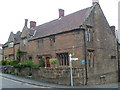
40-44 St James' Street, South Petherton
Fine 15th Century cottages built in Ham stone. The two windows beside the one-way sign are thought to be original.
Image: © Bill Harrison
Taken: 15 Jul 2016
0.04 miles
2
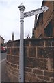
Old Direction Sign - Signpost by St James's Street, South Petherton
Pyramid finial - 1 arm; Somerset SCC pyramid (Sheldon) by the UC road, in parish of South Petherton (South Somerset District), Silver Street junction with St James's Street.
Surveyed
Milestone Society National ID: SO_ST4317A
Image: © Milestone Society
Taken: Unknown
0.05 miles
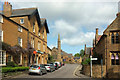
3
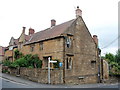
Holbrook House
Once a single residence, this house on St. James Street in South Petherton
has 15th and 16th century features. The main range of the building dates
from the 17th century. The single round chimney is original, the rectangular
ones appear to be 20th century additions. The road off to the right is
Silver Street which becomes the road to Martock.
Image: © Andy Pearce
Taken: 12 Mar 2008
0.05 miles
4
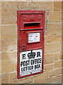
Post box, South Petherton
A fine example of a "Ludlow No. 2" wall box from ca. 1905 outside South Petherton Post Office on St James' Street. "ER" refers to Edward VII.
Image: © Bill Harrison
Taken: 15 Jul 2016
0.05 miles
5
The Post Office, St. James's Street
Shows the location of Image
Image: © Mike Quinn
Taken: 20 Sep 2011
0.05 miles
6
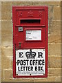
Edward VIII "Ludlow" postbox, St. James's Street
The location of this postbox is shown in Image and Image; and in Image photographed by Eugene Birchall.
Image: © Mike Quinn
Taken: 20 Sep 2011
0.05 miles
7
The Court House, South Petherton
Partly medieval http://www.britishlistedbuildings.co.uk/101056954-court-house-south-petherton#.WcPGJNFrysw
Image: © Jonathan Thacker
Taken: 13 Sep 2017
0.05 miles
8
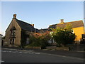
South Petherton: Post Office and Coke Memorial Methodist Church
Image: © Mr Eugene Birchall
Taken: 9 Mar 2010
0.05 miles
9
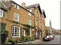
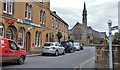
St James's Street, South Petherton
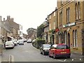
In the foreground is the junction with Silver Street. Past it is a "row of 3 cottages, formerly one house" https://historicengland.org.uk/listing/the-list/list-entry/1188060 . "Said to have been a parsonage ... in C17 was known as Higher House ... south gable has two 2-light windows with late C15/early C16 cinquefoil cusped lights, deep labels with headstops". On the left is the wisteria-clad post office. Ahead at the next junction is the Coke Memorial Methodist Church https://historicengland.org.uk/listing/the-list/list-entry/1345928 , built in 1881. "This church replaced an 1809 chapel on the site, Methodism having come to the parish in 1753."
Image: © Derek Harper
Taken: 27 Apr 2019
0.05 miles