IMAGES TAKEN NEAR TO
Barrow Drive, TAUNTON, TA1 2UU
Introduction
This page details the photographs taken nearby to Barrow Drive, TA1 2UU by members of the Geograph project.
The Geograph project started in 2005 with the aim of publishing, organising and preserving representative images for every square kilometre of Great Britain, Ireland and the Isle of Man.

There are currently over 7.5m images from over14,400 individuals and you can help contribute to the project by visiting https://www.geograph.org.uk
Image Map
Images are licensed for reuse under creativecommons.org/licenses/by-sa/2.0
Notes
- Clicking on the map will re-center to the selected point.
- The higher the marker number, the further away the image location is from the centre of the postcode.
Image Listing (35 Images Found)
Images are licensed for reuse under creativecommons.org/licenses/by-sa/2.0
Image
Details
Distance
1
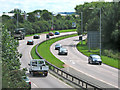
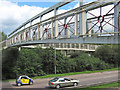
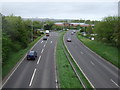
The A358 in Taunton
Looking out of town, towards the M5 junction
Image: © Ken Grainger
Taken: 25 Jul 2009
0.10 miles
2
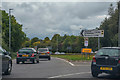
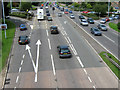
Taunton : The A358
The A358 from the roundabout.
Image: © Lewis Clarke
Taken: 30 Sep 2018
0.10 miles
4
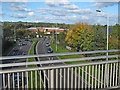
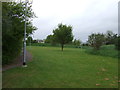
Taunton : Hollywood Bowl Car Park
This car park had a big puddle in it due to heavy rain.
Image: © Lewis Clarke
Taken: 16 Jan 2010
0.12 miles
5
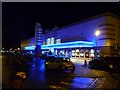
Taunton : The Odeon Cinema
Today, we went to see the film Daybreakers with Sam Neil - there are eight screens in this cinema.
Image: © Lewis Clarke
Taken: 16 Jan 2010
0.13 miles
6
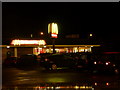
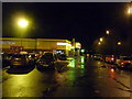
Taunton : McDonald's
McDonald's in Hankridge Farm.
Image: © Lewis Clarke
Taken: 16 Jan 2010
0.13 miles
10
The A358 in Taunton
Looking towards the town centre
Image: © Ken Grainger
Taken: 25 Jul 2009
0.14 miles