IMAGES TAKEN NEAR TO
Holly Close, TAUNTON, TA1 2QW
Introduction
This page details the photographs taken nearby to Holly Close, TA1 2QW by members of the Geograph project.
The Geograph project started in 2005 with the aim of publishing, organising and preserving representative images for every square kilometre of Great Britain, Ireland and the Isle of Man.

There are currently over 7.5m images from over14,400 individuals and you can help contribute to the project by visiting https://www.geograph.org.uk
Image Map (13 Images)


Leaflet Map data © OpenStreetMap
Images are licensed for reuse under creativecommons.org/licenses/by-sa/2.0
Notes
- Clicking on the map will re-center to the selected point.
- The higher the marker number, the further away the image location is from the centre of the postcode.
Image Listing (13 Images Found)
Images are licensed for reuse under creativecommons.org/licenses/by-sa/2.0
Image
Details
Distance
1
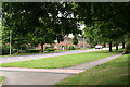
Taunton: Chestnut Drive
Near Upper Holway Road
Image: © Martin Bodman
Taken: 16 Aug 2009
0.17 miles
2
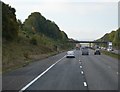
Northbound M5 approaching Taunton (north) exit
Image: © David Smith
Taken: 14 Apr 2011
0.18 miles
3
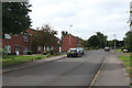
Taunton: Lime Crescent
Near its junction with Upper Holway Road
Image: © Martin Bodman
Taken: 16 Aug 2009
0.18 miles
4
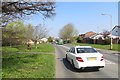
Chestnut Drive
A distribution road in the suburbs of Taunton. Heading towards Holway.
Image: © Richard Webb
Taken: 9 Apr 2015
0.18 miles
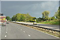
5

Taunton : M5 Motorway
The M5 Motorway between Junction 26 (Chelston) and Junction 25 (Blackbrook Interchange).
Image: © Lewis Clarke
Taken: 22 Sep 2019
0.19 miles
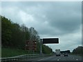
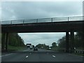
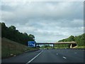
7
Stoke Road Bridge over the M5 near Taunton
Image: © David Dixon
Taken: 25 Jul 2018
0.22 miles
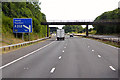
9
Taunton Deane District : The M5 Motorway
The M5 Motorway heading north beyond Taunton.
Image: © Lewis Clarke
Taken: 29 Oct 2013
0.23 miles
10
Bridge carrying road from Taunton to Stoke St Mary
The bridge carries a minor road over the M5 from Taunton (on the left (north-west)) to Stoke St Mary
Image: © David Smith
Taken: 10 Jun 2011
0.23 miles