IMAGES TAKEN NEAR TO
Holway Road, TAUNTON, TA1 2EY
Introduction
This page details the photographs taken nearby to Holway Road, TA1 2EY by members of the Geograph project.
The Geograph project started in 2005 with the aim of publishing, organising and preserving representative images for every square kilometre of Great Britain, Ireland and the Isle of Man.

There are currently over 7.5m images from over14,400 individuals and you can help contribute to the project by visiting https://www.geograph.org.uk
Image Map (Loading...)


Getting Data...Please wait
Leaflet Map data © OpenStreetMap
Images are licensed for reuse under creativecommons.org/licenses/by-sa/2.0
Notes
- Clicking on the map will re-center to the selected point.
- The higher the marker number, the further away the image location is from the centre of the postcode.
Image Listing (29 Images Found)
Images are licensed for reuse under creativecommons.org/licenses/by-sa/2.0
Image
Details
Distance
1
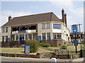
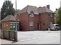
The Flying Horse
A large public house, looking like an inter-war development along with the local area.
Image: © Neil Owen
Taken: 16 Jul 2013
0.09 miles
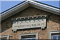
3
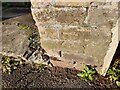
Ordnance Survey Cut Mark
This OS cut mark can be found on the wall between Nos 112 & 114 South Street. It marks a point 20.063m above mean sea level.
Image: © Adrian Dust
Taken: 12 Jul 2023
0.12 miles
4
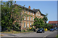
The old Taunton Workhouse
This became Trinity Hospital in more recent years. The building has now been converted to residential use
Image: © Nick Chipchase
Taken: 11 May 2009
0.13 miles
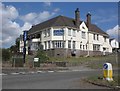
5
School money
King's College Finance House - with guard dogs on patrol if you care to get closer.
Image: © Neil Owen
Taken: 16 Jul 2013
0.13 miles
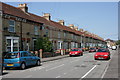
8
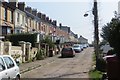
Lane off Holway Drive
Around the back of a row of terraces which stand out amongst the modern suburbs to the north.
Image: © Richard Webb
Taken: 9 Apr 2015
0.16 miles
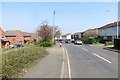
9
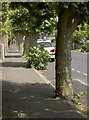
They grew like it
The tree-lined Holway Avenue, where the trees aren't sure if they are on the pavement or in the road.
Image: © Neil Owen
Taken: 16 Jul 2013
0.17 miles
10
Eastleigh Road - Taunton
The only place in Taunton to suffer bomb damage in The Second World War.
Image: © Nick Chipchase
Taken: 11 May 2009
0.18 miles