IMAGES TAKEN NEAR TO
Foldhill Lane, MARTOCK, TA12 6PQ
Introduction
This page details the photographs taken nearby to Foldhill Lane, TA12 6PQ by members of the Geograph project.
The Geograph project started in 2005 with the aim of publishing, organising and preserving representative images for every square kilometre of Great Britain, Ireland and the Isle of Man.

There are currently over 7.5m images from over14,400 individuals and you can help contribute to the project by visiting https://www.geograph.org.uk
Image Map
Images are licensed for reuse under creativecommons.org/licenses/by-sa/2.0
Notes
- Clicking on the map will re-center to the selected point.
- The higher the marker number, the further away the image location is from the centre of the postcode.
Image Listing (5 Images Found)
Images are licensed for reuse under creativecommons.org/licenses/by-sa/2.0
Image
Details
Distance
3
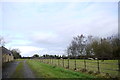
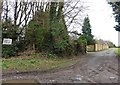
Sheep Paddock at Taepper Court Farm
There is a footpath that runs along this track between the paddock and the farm. It leads north across the farm fields to Ash village.
Image: © Nigel Mykura
Taken: 30 Jan 2016
0.08 miles
4
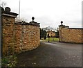
Gateway, Hillview Farm
Marked as Foldhill Farm on the map.
Image: © Roger Cornfoot
Taken: 8 Feb 2017
0.10 miles
5
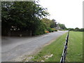
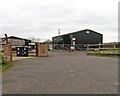
Taepper Court Farm
View north of Foldhill Lane, Martock. A footpath heads north to Ash from here.
Image: © Jonathan Billinger
Taken: 13 Aug 2007
0.10 miles