IMAGES TAKEN NEAR TO
Matfurlong Close, MARTOCK, TA12 6LD
Introduction
This page details the photographs taken nearby to Matfurlong Close, TA12 6LD by members of the Geograph project.
The Geograph project started in 2005 with the aim of publishing, organising and preserving representative images for every square kilometre of Great Britain, Ireland and the Isle of Man.

There are currently over 7.5m images from over14,400 individuals and you can help contribute to the project by visiting https://www.geograph.org.uk
Image Map
Images are licensed for reuse under creativecommons.org/licenses/by-sa/2.0
Notes
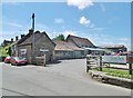
- Clicking on the map will re-center to the selected point.
- The higher the marker number, the further away the image location is from the centre of the postcode.
Image Listing (95 Images Found)
Images are licensed for reuse under creativecommons.org/licenses/by-sa/2.0
Image
Details
Distance
1
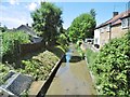
Martock, Hurst Brook
Looking downstream; the brook drains into River Parrett. Seen from Long Orchard Way.
Image: © Mike Faherty
Taken: 2 Jun 2018
0.04 miles
2
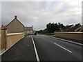
Long Orchard Way
New housing at Martock.
Image: © Jonathan Thacker
Taken: 18 Sep 2018
0.04 miles
3
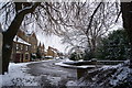
Southern end of Martock looking towards Water street.
Image: © Pam Goodey
Taken: 6 Jan 2010
0.06 miles
4
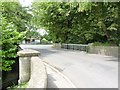
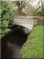
Hurst Bow Bridge, Martock
This bridge has an ordnance Survey benchmark on it. See http://www.bench-marks.org.uk/bm27967 for full description and Image] for view of benchmark.
Image: © Becky Williamson
Taken: 10 Jul 2015
0.06 miles
5
Hurstbow Bridge, Martock
'Rebuilt 1848 to designs of Richard Carver by George Pearse, local mason, using cast iron members by Murch of Bridgwater. Ham stone and cast iron. Segmental arched cast iron ribs over single span, decorated and with "March 1848" cast on outer faces ... Total cost of bridge and walls two hundred pounds.' http://www.imagesofengland.org.uk/Details/Default.aspx?id=424138&mode=adv The bridge carries the B3165 over Hurst Brook.
Image: © Derek Harper
Taken: 13 Mar 2009
0.07 miles
6
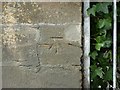
Benchmark, Hurst Bow Bridge, Martock
Ordnance Survey benchmark, described on database at http://www.bench-marks.org.uk/bm27967. For context view, see
Image: © Becky Williamson
Taken: 10 Jul 2015
0.07 miles
8
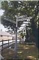
Old Direction Sign - Signpost by the B3165, Hurst, Martock
Pyramid finial - 4 arms; Somerset SCC pyramid by the B3165, in parish of Martock (South Somerset District), by Yandles Woodcraft Centre, junction of Hurst, Water Street and lane to South Petherton.
Surveyed
Milestone Society National ID: SO_ST4518.
Image: © Milestone Society
Taken: Unknown
0.08 miles
9
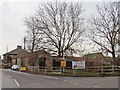
Martock, Yandles
Sawmill with other facilities in Hurst. Sawmill back right, also gallery and café: http://www.yandles.co.uk/
Image: © Mike Faherty
Taken: 2 Jun 2018
0.08 miles
10
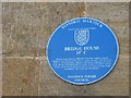
Blue plaque, Bridge House
"William Wynne Westcott, (1848-1925) lived here, surgeon, supreme Magus for the Societas Rosicruciana in Anglia, founder of the Hermetic Order of the Golden Dawn, Master of the Occult, Freemason of Grand Rank. He was a local physician for 9 years, coroner for central London, founder of the Westcott Hermetic Library and author of many books on medicine, the occult and Freemasonary"
Looks like Foucault swung his pendulum a bit around here.
Image
Image: © Richard Webb
Taken: 21 Apr 2011
0.09 miles