IMAGES TAKEN NEAR TO
Stowers Row, MARTOCK, TA12 6EL
Introduction
This page details the photographs taken nearby to Stowers Row, TA12 6EL by members of the Geograph project.
The Geograph project started in 2005 with the aim of publishing, organising and preserving representative images for every square kilometre of Great Britain, Ireland and the Isle of Man.

There are currently over 7.5m images from over14,400 individuals and you can help contribute to the project by visiting https://www.geograph.org.uk
Image Map
Images are licensed for reuse under creativecommons.org/licenses/by-sa/2.0
Notes
- Clicking on the map will re-center to the selected point.
- The higher the marker number, the further away the image location is from the centre of the postcode.
Image Listing (24 Images Found)
Images are licensed for reuse under creativecommons.org/licenses/by-sa/2.0
Image
Details
Distance
1
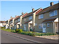
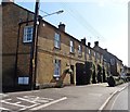
Houses in Martock
This row of Modern terraced housing is in Steppes Meadow just off the northern end of North St, the main road through the village, the B3165.
Image: © Nigel Mykura
Taken: 2 May 2013
0.02 miles
4

Sunrise over Martock
I hope it is going to be a good day!
Image: © Pam Goodey
Taken: 22 Oct 2007
0.11 miles
6
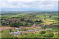
A distant view of Martock from Ham Hill
Image: © Nick Chipchase
Taken: 5 Jun 2015
0.13 miles
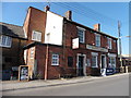
9
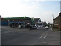
Garage, Stapleton Road
£1.46/l for diesel. April 2011.
Image: © Richard Webb
Taken: 21 Apr 2011
0.15 miles
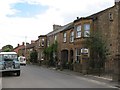
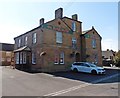
10
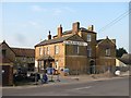
The Railway
Public house undergoing renovation, it is situated opposite the site of Martock railway station.
Image: © Richard Webb
Taken: 21 Apr 2011
0.15 miles