IMAGES TAKEN NEAR TO
Newtown, MARTOCK, TA12 6BQ
Introduction
This page details the photographs taken nearby to Newtown, TA12 6BQ by members of the Geograph project.
The Geograph project started in 2005 with the aim of publishing, organising and preserving representative images for every square kilometre of Great Britain, Ireland and the Isle of Man.

There are currently over 7.5m images from over14,400 individuals and you can help contribute to the project by visiting https://www.geograph.org.uk
Image Map
Images are licensed for reuse under creativecommons.org/licenses/by-sa/2.0
Notes
- Clicking on the map will re-center to the selected point.
- The higher the marker number, the further away the image location is from the centre of the postcode.
Image Listing (4 Images Found)
Images are licensed for reuse under creativecommons.org/licenses/by-sa/2.0
Image
Details
Distance
3
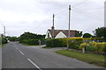
Thorney Road, Kingsbury Episcopi
Looking south from Lockleaze towards the centre of the village of Kingsbury. the village houses are very strung out along the minor road from Stembridge to Muchelney.
Image: © Nigel Mykura
Taken: 5 Aug 2015
0.25 miles
4
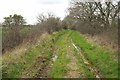
Horsey Drove
A little further along bridleway 40UD061 L 17/95 from Image
Image: © Derek Harper
Taken: 16 Apr 2016
0.25 miles